
As we enter the new fiscal year here in San Diego, we would like to thank all of the advocates that continue to demand safer streets, cleaner air, and a more livable San Diego.
As Barack Obama said, “A budget is more than just a series of numbers on a page; it is an embodiment of our values.”
The City’s adopted FY2024 budget of over $5 billion, unfortunately, shows that our elected officials do not truly value saving lives, combating the climate crisis, or pioneering transformative change. To illustrate this point, consider that the police department will receive $617.1 million, 30% more than the combined amount allocated to Parks ($207 million), Climate Action ($141.6 million), Homelessness ($81.7 million), and Vision Zero ($6.1 million).
The City did not listen to our demands.
Amidst this disheartening outcome, it is crucial to recognize the wins that deserve celebration. Out of our ambitious list of demands, the following initiatives will indeed receive funding in FY2024:
- $33 million towards Strategy 3 of the Climate Action Plan, which is looking to improve bicycling, walking, and transit as viable transportation options
- $2.25 million for the Interstate 5 Underpass bikeway connector (Linking two existing bike paths, the SR-56 and the Sorrento Valley Road multi-use bike path)
- $1.5 million to fix the City's most dangerous intersections
- $1.2 million to implement a traffic calming truck route in Barrio Logan
- $1.2 million to start work on the Normal Street Promenade
- $1.1 million to the Safe & Sustainable Transportation All Ages & Abilities Team (STAAT)
- $50,000 has been granted for the installation of bike racks citywide
- The implementation of the Downtown Mobility Plan will persist, progressing through Phase 3A1 by the conclusion of 2023
This list falls short of what is required to achieve our Vision Zero goal of eradicating traffic-related fatalities by 2025, as well as our Climate Action Plan objective of increasing bicycle mode share to 7%. It does, however, represent a modest beginning. We will continue to exert pressure upon decision makers at the City and County levels, ensuring that safeguarding lives and building a resilient community receive the attention they deserve.
There is a lot of work to be done; stay tuned to get involved with the FY2025 budget and all the other campaigns we are working on to make San Diego a more bikeable and livable city.
Anar Salayev
Executive Director
Bike San Diego
Statement by BikeSD on the San Diego City Council decision to widen SR-56
We are disappointed with the unanimous decision of the San Diego City Council to widen freeway SR-56. This decision contradicts the climate goals outlined in the Climate Action Plan, which calls for a reduction in vehicle miles traveled, and an increased mode shift to alternative forms of transportation.
Transportation is one of the largest sources of greenhouse gas emissions in the San Diego region, and widening freeways encourages more driving, which in turn leads to more emissions. The City Council chose to prioritize short-term convenience over long-term sustainability.
This decision, which was made despite Council President Elo-Rivera’s acknowledgement that “this is not a win from a climate perspective,” shows a lack of commitment to both climate action and vehicle mile reduction.
This is not the visionary leadership that San Diego needs to be at the forefront of our climate crisis.
Thoughts on AB 2097: Places for People, Not for Cars
AB 2097: Places for People, Not for Cars
It has been known for quite some time now that parking increases costs and perpetuates car-centric development. Parking, an amenity so overly subsidized, is seen as a natural right to many Americans. And because most people expect to easily find parking in most destinations, they opt to drive. This preference is then perpetuated by the large amounts of vacant land required to accommodate a parking lot – if a restaurant’s parking lot is 3x the size of the dining area, then all of a sudden it’s not very feasible to walk or bike to it. Take this design and scale it across a city, and you find yourself in a sea of parking lots (which is the very reality we live in today). All of a sudden, the only convenient way to get anywhere is with a car.
AB 2097 blocks city and county governments from imposing minimum parking requirements on housing developments within half-mile of public transit. Maximizing land use density allows for more homes, businesses, and amenities to be co-located at a human-centric scale. This makes it easier for people to walk and bike and easier for cities to provide reliable public transportation. I want to be clear that this is not a silver bullet – for true mode shift to occur, cities across the state need to truly allow for other modes of transportation. That means providing safe, all ages and abilities, protected bike lanes, that means increasing transit frequency and service hours, that means allowing for greater mixed use development, that means slowing down cars and ensuring that all road users feel safe in getting to where they need to go. Those steps, in tandem with this law, would really incentivize Californians to get around using mass transit and active transportation.
San Diego was one of the first cities in California to eliminate parking requirements for housing near transit, back in 2019. Research has shown that the city has subsequently seen an increase in affordable housing production (and higher housing production overall). In fact, one year after the reform was implemented, San Diego saw a fivefold increase in the total number of homes permitted through the density bonus program.
Of course there will always be people unhappy with change. A lot of pundits argue that this law will disincentivize developers from including any parking in their developments. Studies in Buffalo and Seattle, cities that struck down street parking in the 2010s, showed that a number of developments kept the same number of parking spots that they would’ve had before the reform. The key takeaway here is that AB 2097 gives developers and tenants options. Because developers aren’t required to build parking, their development expenses can be kept lower, incentivizing affordable housing. And tenants that do not own a car could move in and not have to pay more for an unused parking space.
These reforms are especially necessary given our current climate crisis. We know now that the post-war suburban (and exurban) experiment was a failure – ignoring all other problems, there is just not enough space to provide every single person a single family home with a front lawn, two car garage, driveway, and backyard swimming pool. Our sprawling cities require more resources to build, more money to maintain, and more miles to be driven. Not only is this ecologically unsustainable, but also economically irresponsible. As cities grapple with the looming climate crisis and work to reduce carbon emissions, they need to deploy every possible strategy – from reducing vehicle miles traveled to preserving ecological biodiversity. AB 2097 is one of these strategies.

Re: Sustainability & Mobility Department’s Balboa Drive Design Opportunities and Next Steps
Re: Sustainability & Mobility Department’s Balboa Drive Design Opportunities and Next Steps
Background
At the Balboa Park Committee meeting on October 6th, the City’s Sustainability and Mobility Department presented a proposal for redesigning Balboa Drive in Balboa Park.
This redesign would align with the upcoming slurry seal project (#2323) which is slated to take place between April – October 2023. The presenters proposed increasing parking for the current 446 spaces to 575 (a nearly 30% increase) to “…offset parking loss on Park Boulevard…”
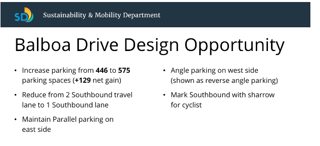
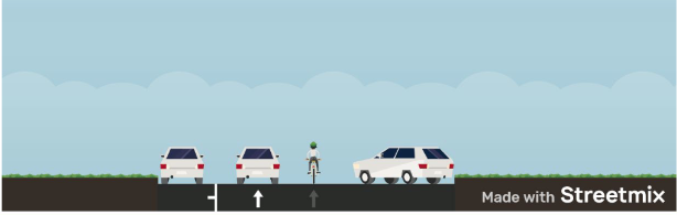
To provide some context here, the City recently approved a redesign of Park Boulevard, which would remove a general purpose lane and some parking in both directions to make room for bus-only and protected bike lanes. This Park Boulevard reconfiguration, which allows for a safer and more comfortable experience for pedestrians, bicyclists, and transit users, would result in a loss of ~175 parking spaces in a park that has nearly 7,500 free parking spaces – about 2%.
But what does the City decide to do to “offset” this monumental step forward…?
In order to offset this marginal loss of parking, the City has proposed adding more parking elsewhere in the parking, a goal that ignores the City’s own Climate Action Plan.
Worse yet, they propose to do this with angled parking, a redesign that not only further incentivizes automobile travel, but is actually associated with higher rates of collisions than parallel parking.
Problem
Our world is changing — every day we see the consequences of climate change impacting more and more people. In the state of California, thanks to eighty years of urban sprawl, subsidized parking, and an ingrained car culture, over fifty percent of greenhouse gas emissions come from on-road transportation. In an effort to reduce this, San Diego’s ambitious mode shift goals are looking to increase the percentage of bicycling trips to 7% (from 1.4%) and transit trips to 10% (from 4.5%) by 2030.
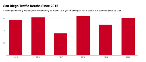
In parallel, we are facing the crisis of traffic violence: four of the most dangerous metropolitan areas for pedestrians are in California. San Diego has set ambitious Vision Zero goals: aspiring to have zero traffic related fatalities and severe injuries by 2025. Though, the reality, thus far, has looked more like this…
The changes made on Park Boulevard are a brilliant step towards achieving these ambitious goals. It makes biking, transit, and walking more comfortable and will encourage more San Diegans to opt for one of those options when traveling to (or through) our crown jewel.
But we’re adding more parking…?
Adding more parking disincentivizes other ways of transportation to the park, and inherently prioritizes car-based transportation, actively working against the City’s stated goals. The City repeatedly prides itself on the strides made with regards to the Climate Action Plan and Vision Zero, but refuses to accept that adding more parking during a climate emergency is absurd.
We’ve been hearing a lot of talk about climate action and vision zero. Unfortunately, when it comes down to making real, material change in San Diego, we need a dozen meetings to go forward and just one to go back.
Where do we go from here?
Here are the facts:
Balboa Drive is frequently used by bicyclists, families, and dog walkers to traverse the western mesa. We can see this when looking at heatmap data on both Strava and RideWithGPS.
Furthermore, according to the City’s Sustainability and Mobility team, the 446 parking spaces has a ~30% occupancy rate – which means, at any given time, only thirty percent of the parking spaces are utilized. City’s oftentimes plan to add new parking when utilization is above 85% – in this case, it seems like there’s plenty of parking for anyone that might need it
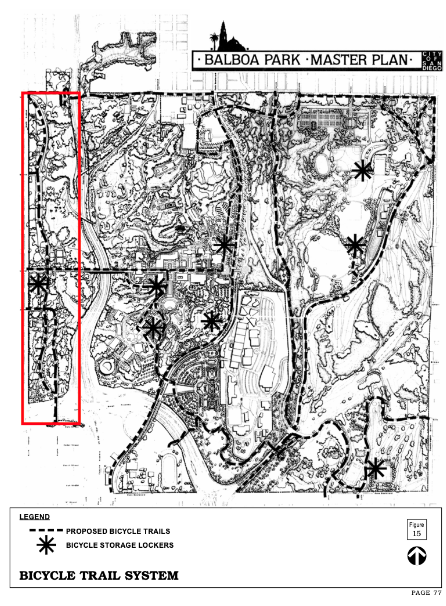
Finally, the 2012 Balboa Park Master Plan explicitly proposes that Balboa Drive (or some path alongside it) serve as a bicycle trail (below). This trail would connect neighborhoods to the Cabrillo Bridge, bowling greens, dog parks, and playgrounds.
Given all this, here are BikeSD’s recommendations for Balboa Drive’s reconfiguration:
1. Slow down traffic
Reduce Balboa Drive’s width
Reduce the number of vehicle lanes from two to one
2. Enhance active transportation access
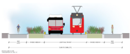
Add a bi-directional class IV cycletrack on the east side. This configuration is in line with the City’s “Class IV” first approach
3. Maintain curbside parking on west side
This could be all be completed as part of the next street resurfacing effort and would support:
- 2022 Climate Action Plan goals
- Vision Zero goals
- The Balboa Park Master Plan
We ask the City of San Diego to no longer offset the good it tries to do in one area by doing worse elsewhere. If we absolutely have to optimize parking availability, we recommend that the City set market-rate pricing for parking spots in Balboa Park and use this revenue to make further improvements to our crown jewel (More information here).
BikeSD Voices: An Open Letter I Sent to the Planners behind the Hillcrest Plan Amendment
BikeSD Voices: An Open Letter I Sent to the Planners behind the Hillcrest Plan Amendment
Author: Nevo Magnezi
I recently attended the Uptown Planners Plan Hillcrest subcommittee meeting, Mobility Network Concepts, on June 30th. Or in plainspeak, planners and consultants from the city presented to community members and board members (appointed from Uptown Planners) transportation concepts that will be incorporated as part of the upcoming Community Plan Update for Hillcrest. You can learn more about this process on their website, and can see the slide deck they presented on June 30th, which I based my response on, here: Hillcrest CPG – Mobility June 2022 PDF
As someone who has been advocating for better mobility for several years, I wanted to provide new advocates an example of some of the key points I make. Admittedly, this isn’t one of my best worded emails (more like my manic midnight brain talking), but I thought it could be useful regardless.
Feel free to take my email as an inspiration to write your own with regards to mobility in Hillcrest.
Dear Ms. Mulderig, Ms. Brizuela, and Ms. Chen,
My name is Nevo Magnezi. I live in Hillcrest (have lived in both the east and southwestern portions of the plan focus area) and have been attending the Plan Hillcrest subcommittee meetings more or less since they began. I also volunteer for Bike San Diego.
I am reaching out because I’d like to provide some feedback on the most recent presentation. I am grateful for the visioning and options that the city and Chen Ryan Associates are providing and I think that whatever the outcome, it will be an improvement over the status quo.
My main concern is that planners were too quick to abandon the idea of envisioning University Ave as an active transportation and transit corridor. There are many examples around the world, the country, and, once the Gaslamp Promenade is implemented downtown, even the city, of walkable commercial corridors with very limited private automobile access, other than emergency vehicles and deliveries during specified hours.
One of my favorite examples is of the Jerusalem Light Rail, which you can see in this video: https://www.youtube.com/watch?
By recommending a vehicle network that retains general vehicle access to University Ave, I fear you will be robbing residents and visitors of the urban linear park experience that you are advocating for in other parts of the plan. The issues you identified in the presentation will certainly need to be addressed at the time of implementation, but are, for the most part, not major issues.
Your presentation claims that Option 1 would eliminate access to Fire Station No 5. Most emergency calls (65 percent) are for medical events– eliminating fast-moving traffic that cause serious injuries and fatalities and promoting a healthy lifestyle through urban design is one of the best ways that urban planners can reduce the number of emergency calls made in the first place. But even beyond that, I hypothesize that even under Option 2, emergency responders would be more likely to use the transit lanes over the general vehicle lanes anyways due to the fact that the transit lanes will, by design, should see no congestion. It seems to me very backwards that we would need to maintain high speed vehicle access so the ambulance can get to us quickly after we are run over by a vehicle that’s there because we needed vehicle only access for the ambulance. I claim to be no expert on the considerations of emergency vehicle response times in people-centric streets, but I would like to share this resource I found on the NACTO website “Best Practices: Emergency Access in Healthy Streets.”
Three of your major issues are regarding traffic circulation and congestion. It sounds like you are taking an older Level Of Service approach towards the plan area rather than a reducing Vehicle Miles Traveled approach. In the same plan, you include light and commuter rail and low stress protected bikeways. Under these schemes, people will be moved by walking, biking and transit facilities by a factor that will dwarf the number of people moving by private automobile. If transit headways or signal timing for bikeways are not considerations of the plan amendment, then why should vehicle congestion on nearby freeways be? This approach fundamentally favors the status quo and will not allow San Diego to achieve its climate action or Vision Zero goals. Caltrans is one of the agencies responsible for 55 percent of San Diego GHG emissions coming from cars and maintain right-of-way that is responsible for countless collisions that affect vulnerable road users. The fact that even basic painted bike lanes disappear when going over their right-of-way, such as University Ave over SR-163, shows how much contempt that they hold for my life and the life of anyone not in a car. Congestion on SR-163 on-ramps cannot and should not be a concern for the Hillcrest Plan.
Finally, there is the issue of deliveries. If the Gaslamp Promenade, which is being planned and funded as we speak, can already claim per their website that “the Gaslamp Promenade will be open for deliveries from 3:00 a.m. – 11:00 a.m., seven days a week,” then why are deliveries a barrier to implementation for our long-term planning just two miles away? With deliveries, and with all of these points, the Gaslamp Promenade sets an important San Diego precedent (since we seem so eager to disregard examples from any city other than our own). If a Gaslamp Promenade, then why not a Hillcrest Promenade?
My next concern is regarding the recommended Bicycle Network. As I stated during my comment, sharrows don’t do anything. This isn’t just my perspective. According to a 13 year study of a dozen cities, it is safer to not have them at all. I am grateful that planners were able to minimize them from the recommended plan in favor of other facilities, but I would also strongly encourage the amended plan not to have them at all. Instead, it would be better to designate them all as “Enhanced Class III- Bike Boulevards.” This would reinforce to those implementing the plans to not simply “slap a sharrow on it,” but rather implement true traffic calming. I think it’s also important to qualify both these and all bicycle boulevards that the street must be designed (per NACTO), to be with a target vehicle speed of less than 20mph and volume of less than 2000 ADT, or target speed of 25mph and less than 1500 ADT.
For places where you don’t intend for those speeds and volumes, such as Sixth Ave and parts of First Ave, it is negligent to suggest that no bike facilities (which is what sharrows are) are sufficient. This is an area slated for a lot of development, and connects directly to San Diego’s Crown Jewel, Balboa Park, in the case of Sixth Ave, or a massive medical complex with tens of thousands of employees, in the case of First Ave. I strongly encourage you to include Class IV facilities as part of the plan, or simply acknowledge that you intend hardly anyone to feel safe and comfortable biking there at all.
Regarding the planned Class II – bike lane facilities, I think it is also important to qualify these with the point that they are only appropriate for streets with target speeds of 25mph or less and volumes less than 6000 ADT. In the example of Robinson Ave, this would imply that the target speed would be reduced from 30mph to 25mph, if the plan were to be implemented today. Robinson Ave between Tenth Ave and Park Blvd is also a wide street with low-volumes, and can be difficult to cross as a pedestrian. I think it would be a great candidate for the extension of the Landis-style roundabout treatment that SANDAG completed east of Park Blvd, and that will connect to Robinson Ave in Hillcrest via an elevated path.
Thank you again for your work. I realize that my email is a bit more long-winded than I intended, but I would appreciate a discussion regarding any or all of the above points.
Sincerely,
Nevo Magnezi
Hillcrest Resident