
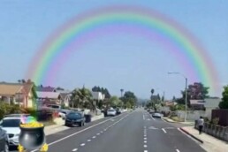
Finding the Gold in Advisory Lanes
I dream of quiet, safe, neighborhood streets with networks of bikeways that promote efficient, healthy, and joyful commutes near and far, for all ages and abilities. After attending Circulate’s Vision Zero Coalition meeting and the Mira Mesa Town Council this evening, I am providing an update to the previous article about advisory bike lanes as new bicycle infrastructure for San Diego.
There is gold to be found on Gold Coast Drive and I'm hoping it will be dispersed throughout the city, in neighborhoods that are frustrated with high speed, cut through traffic. Gold Coast Drive in Mira Mesa, Evergreen in Point Loma, and many other streets are great candidates for this new type of road design to create safer streets by calming traffic speeds through our neighborhoods. The benefits of these types of lane markings are a reduction of vehicles on the street, lower vehicle speeds, quieter neighborhoods, less pollution, and safe access to key destinations. As a property owner, that sounds pretty nice.
Unfortunately, much of the Mira Mesa community hasn’t realized the value of the innovative design, known as advisory bike lanes. On Monday, many expressed concern over perceived dangers such as increased traffic, head on collisions, and drunk drivers. Lacking accurate information about how advisory bike lanes work, and how successful they’ve been on streets with similar characteristics, they argued that advisory bike lanes are inappropriate for Gold Coast Drive. However, research has found a significant reduction of crashes on roads where advisory bike lanes were implemented; an aggregate 44% reduction in crashes.
There is an alternative solution of providing protected bikeways that would be safer, but this option requires removing parking spaces which is not an easy sell. Gold Coast Drive is a neighborhood street with a designated 25 miles per hour speed limit, therefore, edge lanes are an appropriate design.
Many mentioned last night that Gold Coast Drive is a cut through used by drivers to avoid congestion on Mira Mesa Boulevard. Hello neighbors, wouldn’t your quality of life and property values improve if you lived on a more peaceful road?
A silver lining is that Gold Coast features three public schools along its length and this type of bike facility will create safe routes to schools, SRTS. Imagine our children enjoying the ride to school, chatting and laughing with friends on a bike, scooter, skateboard, or whatever active mobility option they choose. After six years of leading 10-12 year olds to school, it was evident, and supported with research, that active transportation and physical activity has positive effects on the brain and on school performance. Our younger folks are the leaders to break free from the car dependency that is choking our streets, polluting our air, and changing our climate and we must provide the opportunities to empower them. Many have experienced the independence and the fun of electric bicycles and we must embrace this healthy way to move in San Diego. Please help dedicate a safe space for them to ride and establish healthy lifestyles.
Shout out to the older folks like me. Try riding an e-bike to enjoy your community, improve your health, and reach your destination feeling refreshed and energized. E-bikes flatten hills, make it easier to carry heavy loads, and go longer distances while filling your body with exhilaration and life. You not only can watch your grandchildren ride to school with their friends, maybe you will be lucky enough to join them.
If you have questions or are still unconvinced, please reach out and we can ride an e-bike together to discuss and experience the real dangers of sharrows and understand why more people don’t ride bikes in beautiful, climate kissed, San Diego. As a car driver, I understand the frustrations of a slower bicycle rider impeding the way. Advisory bike lanes make mobility more efficient for all, as it becomes easier for drivers to navigate around cyclists, giving options to legally move along the road in synchronicity with cyclists and other drivers.
Advisory lanes make our neighborhoods safer, quieter, and more enjoyable. I hope Mira Mesa and Point Loma folks will learn about them, be open to change, and support the city’s efforts to make our streets safer for all.
Your Bike Friend.
Nicole BurgessNicole23ob@gmail.com
Edge Lanes May Already Have the Desired Effect
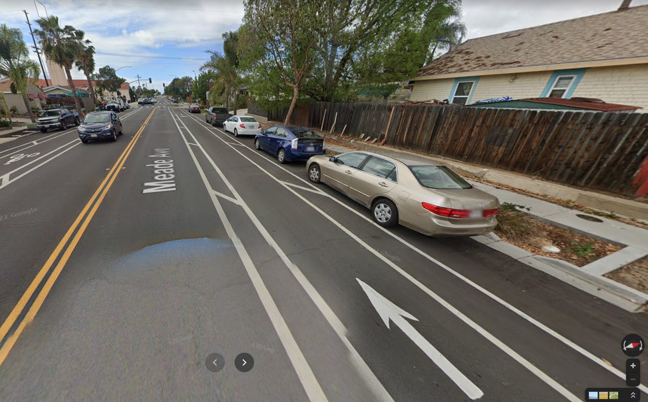
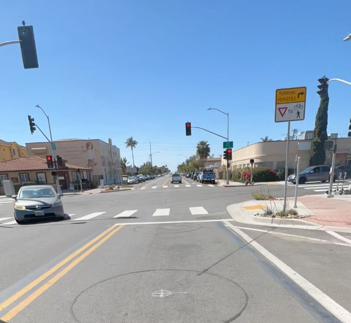
Last Thursday [3/31/22], I encountered new lane markings on freshly resurfaced Evergreen St, part of my daily commute in Pt Loma. Surprised, I looked up details of the design now referred to as edge lanes, and started following news reports and associated discussion. Rather than a center stripe down the middle of the road to designate two way car traffic, they designate a center car lane with dashed bike lanes on either side. The idea is that cars travel down the middle of the road, and when approaching an oncoming vehicle, merge into the bike lane when safe to do so, or slow to fall behind a cyclist - a very similar maneuver to how cars regularly interact with me on Evergreen st.
One of the common fears voiced at community meetings or news interviews are of a head-on collision between cars. The roads generally selected for this treatment are residential, and carry a 25 mph speed limit. These are speeds chosen such that a driver has sufficient reaction time and braking distance if a child runs into the street, or a car blindly backs out of a driveway. If you were to encounter a car heading straight at you, what would be your reaction? Most likely to get out of the way, and/or slow towards zero mph. A collision between cars traveling at zero and 25 mph is not something anyone wants to experience, but thanks to decades of crash testing, a vehicle occupant would likely fare far better than the roughly 10% of pedestrians or cyclists that die when struck by a motor vehicle at 25 mph.
Does this fear reveal something we know about our residential roads but don’t explicitly mention? That people drive too fast and make it unsafe? We have a national epidemic, with pedestrian and bicyclist deaths rising approximately 40-50% over the last decade. Rather than ignore the underlying problem and hope that it will go away, or attempt to fix it through education or enforcement of speed limits, city engineers decided to try a new solution. They changed our perception of traffic flow using paint. Many people who are upset, in their calls to restore the previous road design, may miss the larger picture. Or if they don’t, perhaps they have different ideas on what could be done to address it. And this is where we should center our discussion - on how to best reduce motor vehicle speeds on our residential roads, and incidentally, roads like Gold Coast and Evergreen that service schools.
It is clear that business as usual has not solved the problem, so we need to try something different. A review of edge lane roads in other communities in the US and in Australia, have concluded that this treatment reduced crashes by 44%. And this doesn’t include additional examples we can draw from Denmark, or The Netherlands, which developed their cycling culture through decades of policy decisions.
As a cognitive scientist, I study perception, attention, and how we plan our actions. We smoothly navigate our environment by subconsciously predicting the future, hundreds of milliseconds at a time. We monitor how incoming sensory information matches our predictions, and adjust our movements as necessary, like an outfielder chasing a fly ball. It is startling and upsetting when we encounter a familiar scene that provides conflicting information: paint markings suggesting a one lane road where previously two lanes coexisted. This forces us to recalibrate our predictions and our driving behavior. Knowing we have to share space with other vehicles demands more attention. And humans are notorious for choosing to endure pain rather than perform a difficult mental task. But maybe a residential road demanding more attention is a good thing.
So while the city pauses its rollout of the new street design, and we have time to learn about navigating edge lanes, let’s think about how we can make our streets safer for everyone, rather than rush to restore the previous street design. As I commented in the Mira Mesa Town Council meeting, if the changes lead to drivers slowing down, some of the desired effects may have already been achieved.
Georgia-Meade Bikeway
Some thoughts and next steps
Description
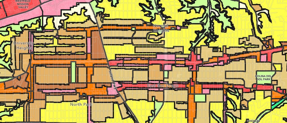
The Georgia-Meade Bikeway is a 3.5 mile segment of the greater North Park | Mid-City Bikeways, which is a 13 mile network of bike corridors that connect the Mid-City neighborhoods north of Balboa Park to Downtown. Meade runs horizontally from Kensington in the east to University Heights in the west, at which point the bikeway extends south via Georgia into North Park.
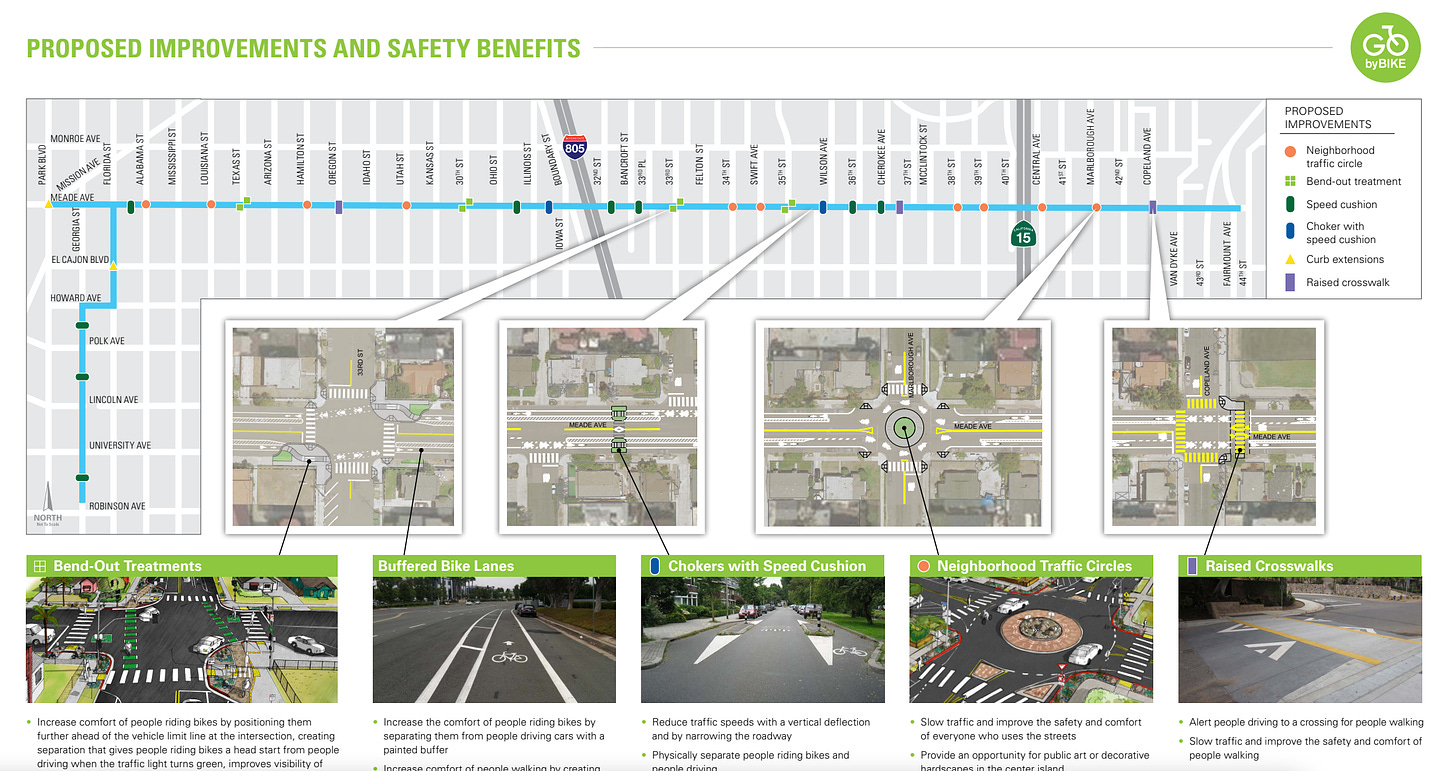
On the ground, Meade Avenue has been given a dramatic road diet, whereby roads have been narrowed to allow for Class II bike lanes. Though some might’ve preferred Class IV bikeways, the combination of Class II and punctuated traffic calming measures (roundabouts, raised crosswalks, and chokers) on this lower traffic volume road (compared to El Cajon Blvd., Madison Avenue, or Adams Avenue) should be sufficient. The improved road elements are meant to decrease the likelihood of a head on collision, reduce traffic speeds, and make active transportation both on and off the road a more comfortable experience.

Benefits
The Mid-City neighborhood consists of over 130,000 residents spread out across some of the most densely populated communities in San Diego. On top of the population density, Mid-City also contains some of the most mixed-used communities in the city. This fusion of residential, commercial, and recreation makes Mid-City a great place to implement more pedestrian/bicycle oriented design. The Meade-Georgia Bikeway, allows residents from the more residential neighborhoods of east Mid-City to easily access the business districts scattered across the western portion (e.g. North Park via 30th Street, Adams via 35th, Normal Heights via 33rd, University Heights via Park Blvd., and the entire strip of businesses along the parallel boulevard, El Cajon).
By inducing greater demand across this east-west corridor, the Mid-City community can reduce vehicular traffic through these denser, pre-war neighborhoods. Most significantly, this greatly decreases the probability of vehicle-pedestrian collisions. Other potential benefits include reduced traffic congestion for those that absolutely must drive and decrease demand for parking in the various business districts (a popular point of contention when discussing non-car infrastructure). Some potential long term benefits are an improvement in air quality for residents living on or near the corridor, improved transit efficiency, and longer pavement lifecycles.
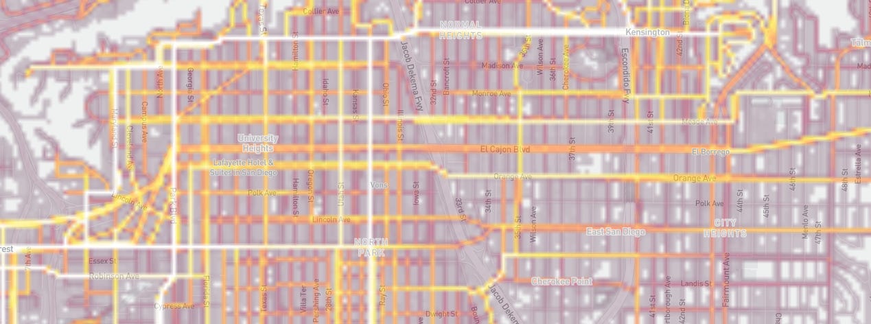
Though the city has not implemented any bike counters on this route, preliminary heatmap data from both Strava and Ride With GPS show promising bicycling activity along the Meade-Georgia Bikeway.

Feedback
I live in Kensington and use Meade almost every single day. Most mornings, I use it to get to the gym in University Heights. During the day, I use it to visit stores and businesses on 30th, Adams, or El Cajon to grab food and run errands. It’s even comfortable to ride along in the evening (if a little dark), on days where I’m coming back from seeing friends in Hillcrest, University Heights, or North Park. I love seeing fellow bicyclists ride past, residents walking their dogs, homeowners tending to their yard, and businesses opening up for the day as I commute between the small neighborhoods sprinkled across Mid-City.
The segment between Marlborough and Georgia is generally fine though there are a couple of things that can be improved.
- There are 10 roundabouts (or, traffic circles) scattered throughout Meade Avenue. Roundabouts are great: they slow down traffic, reduce head-on and side impact collision frequency and severity, and allow for decorative landscapes on what would otherwise be a patch of grey concrete. However, the striping pattern upon entry can lead to some confusion. In the picture below, you’ll notice that the bike lane abruptly ends and forces a quick merge into the sharrow right before entering the roundabout.
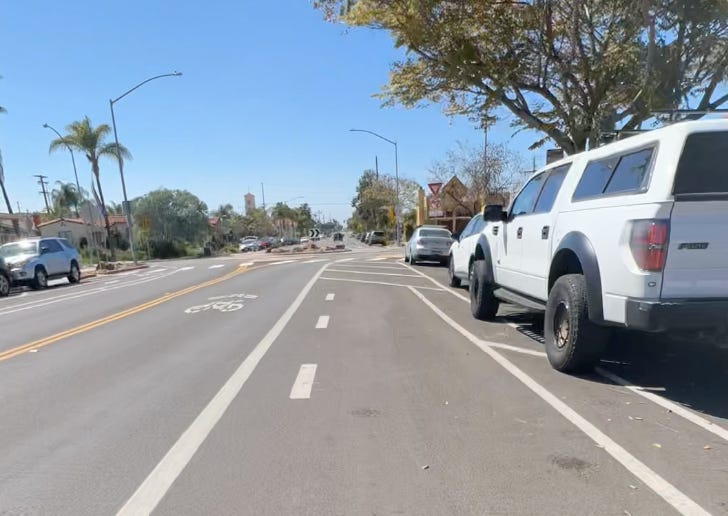 Generally, this maneuver can be done thoughtlessly, thanks to the relatively low volume of traffic present at any time. Nonetheless, I think more clear striping would go a long way in making Meade Avenue truly for all ages and abilities.Other cities have solved this problem by using colored (usually green) pavement and way-finding signals. In the case of the above roundabout entrance, I’d like to see the bike path curve into the traffic lane using green (or red, to follow the Dutch) paint and clearer way-finding.Here are a couple of examples from Austin and Salt Lake City(below) has done a great job of demarcating bike paths through wide intersections and sudden chokepoints.Austin, TX uses white stripes and sharrow markings to demarcate the recommended travel path for bicyclists across a wide intersection (nacto.org)An abrupt choke point in Salt Lake City, UT is clearly demarcated with a green lane and sharrow markings (nacto.org)
 - Meade Avenue intersects with 30th Avenue, another bikeway that was recently opened. Despite both of these individual bikeways being terrific places to ride, the junction between them feels more like an afterthought. In the picture below, I’m facing west on Meade with the intent of turning left onto 30th. To do so, I need to wait at this intersection, yield to oncoming traffic (because this is an unprotected left turn), and then turn through the intersection. Again, not a deal breaker, but an element that can certainly be improved upon, especially if we’re wanting to encourage people of all ages and abilities.
 The typical strategy here would be to add a bike box to the right side of the intersection on 30th, so a bicyclist would position herself there when Meade Avenue is green and then continue south when 30th turns green. I think that requires too much waiting for what isn’t a terribly busy intersection. A more simple change would be to allow for a leading left turn signal which would benefit both left-turning bicyclists and vehicles. Obviously, the pedestrian crosswalk signal would defer to left turning vehicles.
These issues are not specific to the Georgia-Meade bikeway - similar bicycle connectivity issues can be found throughout San Diego (in that interactive map, a lot of the blue and green lanes are extremely uncomfortable for bicyclists, e.g. El Cajon Blvd ).
Indeed, many of the existing bikeways may be great for commuting but fall short when trip chaining ( journeys that consist of numerous shorter trips) is required. As a remnant of mid-century modern urban planning, many bicycle corridors are focused on commuters, that is, getting riders from point A to point B, while not providing the necessary connectivity to comfortably access everything in between.
Next steps
San Diego’s bicycling network and culture are in its early stages: in 2018 the city was awarded Bronze status by The League of American Bicyclists, with one of the recommendations to achieve Silver status being:
Continue to expand the bike network and increase connectivity through the use of different types of bicycle facilities appropriate for the speed and volume of motor vehicle traffic on each road
It is encouraging that our current mayor, city council, and regional government (SANDAG) continue to push for more robust bicycle and pedestrian infrastructure. In the 2021 Regional Plan, there are dozens of projects dedicated to Active Transportation, one of the main categories of focus (Appendix A: Transportation Projects, Programs, and Phasing, Page 6), with $292 million allocated to regional bikeway projects. San Diego City is allocating $28.1 million towards their Vision Zero initiative, including $11.9 million for bicycle facilities (Adopted Budget Fiscal Year 2022, Volume 1: City Budget Overview, Page 19).
In fact, the city recently announced that Park Boulevard would receive protected bike lanes between Adams Avenue and University Avenue. This is a great extension of the existing east-west bikeways (including Georgia-Meade) that cut through Mid-City, allowing easy access to the many businesses and residences that line Park Blvd.
The next step is ensuring that the Park Blvd. improvements are expanded into and through Balboa Park. This would provide a safe path from Mid-City via Uptown into Downtown on a route where we are already seeing a large volume of bicycle activity (Strava heatmap and Ride With GPS heatmap). We would like to see this corridor upgraded to a Class IV bikeway. This would go a long way in encouraging an increase in bicycle trips between two significant commercial and residential cores, including numerous educational and cultural institutions along the corridor. If you would like to help push this forward, please visit the campaign page on BikeSD.org and write to the city!

Advisory Lanes in San Diego
“It is a whole new way for drivers and cyclists to share the road.” City of Ottawa
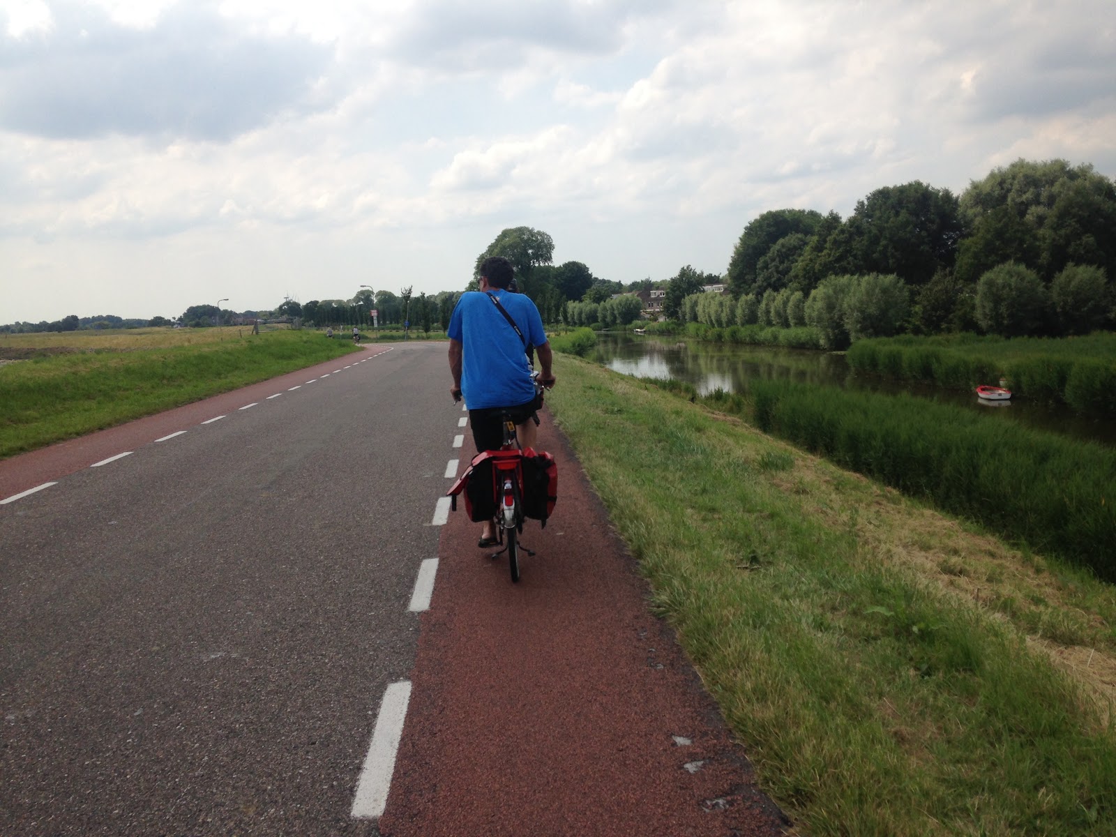
I first experienced Advisory Lanes in Holland in 2014 on a bike barge trip with my family. This was a new type of bike facility to me and I liked them. Below is a photo from the trip that shows a great visual of an advisory lane In Holland. I especially appreciate the different colors of asphalt that are used to differentiate space for different types of users. As one can see, space is dedicated to a safe pathway for people on bikes and other rolling devices. Check out this one minute video to quickly learn how Advisory Bike Lanes work for cyclists and drivers. We do believe it is an intuitive street design treatment that drivers and cyclists will learn to use quickly.
As a long time advocate, I was thrilled to hear that our City is recommending and implementing the use of Advisory Lanes in San Diego. In May, City staff, Everett Hauser, provided a brief introduction to the Mobility Board for the use of Advisory Lanes on Hancock Avenue. I personally believe it will be an improvement for all and is a great compromise for businesses, parking, and active commuters along this corridor with limited street space.
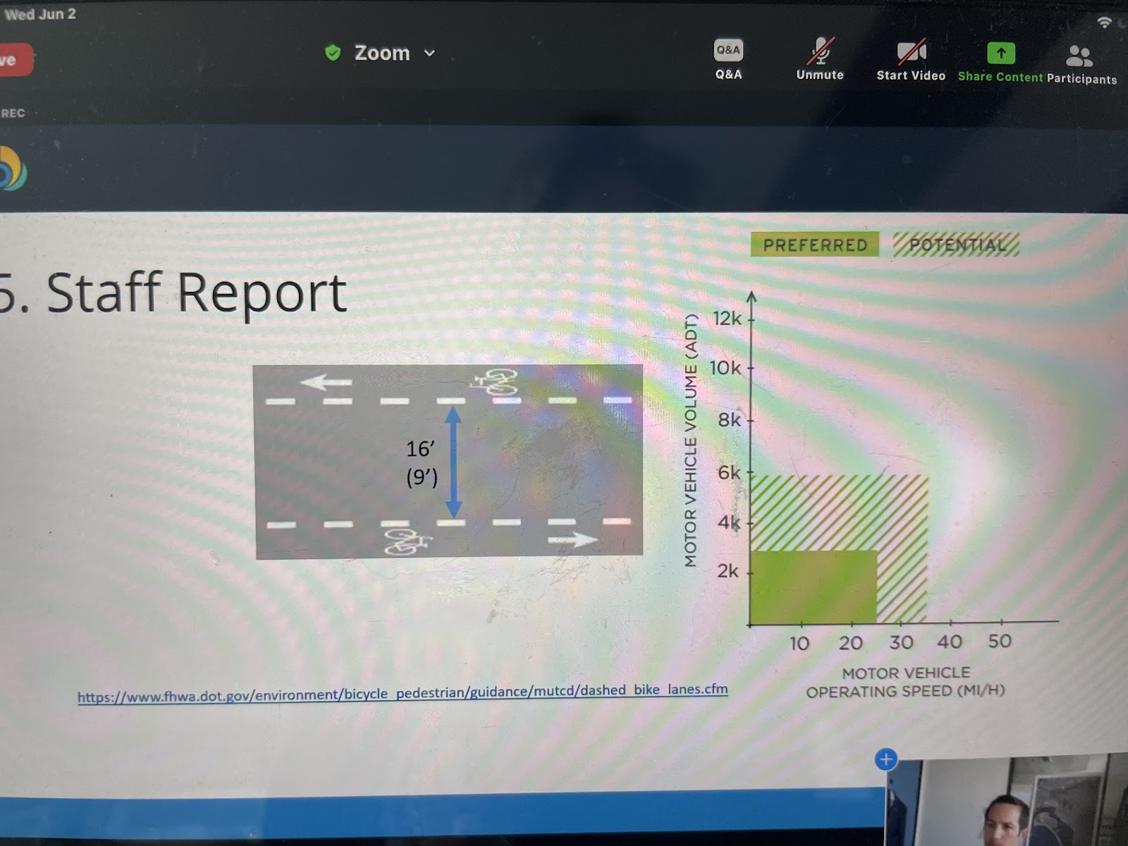
In June, Everett updated the Mobility Board with criteria being used for evaluating future streets for Advisory Lanes. Below is the table presented. It shows Advisory Lanes will be evaluated for narrow streets with limited space, low volume traffic and low volume speeds. It was clarified that streets with parked cars will be considered, as straight-in parking is being proposed for Hancock. As noted, this type of treatment will be used on streets designated in the Bicycle Master Plan that will be resurfaced with slurry seal or overlay treatment. Check out streets.sandiego.gov to view upcoming street resurfacing projects.
If you have ideas or suggestions that you think advisory lanes would be a good fit in your neighborhood, please feel free to share with BikeSD to gain support and help advocate for innovative paint treatments that prioritize safe pathways for people on bikes. If you’re a fan like I am, please send Mayor Todd Gloria an email. Send gratitude and encourage more.
If you like to ride, we recommend to do so often. 😊
The Time is Now
We cannot fear change, we must adapt.
In the swell of pivoting to ensure small businesses survive the ever-changing landscape of pandemic-related restrictions; the City of San Diego temporarily eased restrictions on establishing parklets.
Let’s make temporary permanent. Let the parklets stay.
As San Diegans, we are accustomed to and often prefer opportunities to dine outdoors. With our average 75-degree and sunny weather, San Diego is in the perfect climate position to encourage and support parklets.
This also provides a perfect climate position to encourage and support cycling. The dedicated bike lane on 30th Street is an integral part of the North Park of the future.
Close your eyes and imagine a vibrant, people centric, 30th Street with fewer cars, more people meandering between establishments and more people riding up to their favorite restaurant - imagine 30th Street busy, but with far few car horns.
Since the shutdown a year ago, there are now over 450 businesses leveraging parklet space as business space to serve their customers. It is a wonderful sight to behold and is one many would like to see in San Diego permanently. We love it and believe it is a healthy, vibrant, wonderful future for our business districts.
Unfortunately, there is a conflict on 30th Street between a long anticipated paving project and the parklets we wish to remain in operation. We believe there is a solution for these businesses’ parklets to stay permanently after businesses are opened to indoor dining. Timing is everything. If we do not act swiftly, we will lose the majority of the parklets that we have learned to love and enjoy.
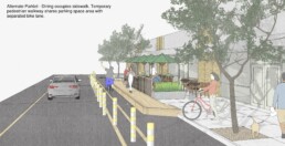
Among the parklet designs available from the City San Diego, BikeSD is advocating for an option that is a win for everyone. We spoke with several North Park business owners regarding this particular parklet design and received a majority of enthusiastic and optimistic responses. There was also an overwhelmingly positive response to the upcoming bike lane, too.
This alternative design moves the parklet to the sidewalk while providing a safe ADA walkway in the street right of way. This eliminates people walking through business patrons and allows for a continuous business. No wait staff weaving through tables and pedestrians. It creates a cohesive environment where customers can hear the music, see the televisions and feel like part of the venue while enjoying the outdoors. Lastly, but critically, it provides the space for a continuous bikeway that avoids conflict zones. This is a solution that can support businesses to continue outdoor dining past the pandemic and into a more vibrant people centric city.
We want to continue supporting our North Park businesses. Join us and ask city staff and Mayor Gloria to work on a solution for all, quickly and efficiently as we support the upcoming resurfacing project and want businesses to adapt and be prepared for the spring and summer season.
Let’s act quickly and efficiently so we can support the upcoming resurfacing project, allow businesses to retain their parklets and be prepared for the spring and summer season.
Let’s be bold. Let’s take this opportunity to construct 30th Street for all of North Park, to be a leader for the rest of San Diego.
Who is ready for bike parties on a parklet filled 30th Street? We are ready.