
Letter Sent to the Mayor to Support a Safe Bicycle Facility on Washington Street
Dear Mayor Kevin Faulconer & City Staff,
We request the City of San Diego immediately address the public safety hazard on eastbound Washington Street (east of India Street) by returning the Class II bicycle facility to the breakdown lane on the south side of the road. The bike lane symbols formerly in this location were painted over without City permission, to add free street parking. As a result, a 66-year old bicyclist riding eastbound on Washington on August 21st, 2020 was struck by a car and critically injured and the driver fled the scene.
This segment of Washington was identified by the City as a “High Priority Bicycle Project” in the 2013 Bicycle Master Plan, and is a designated City bike route. SANDAG also identified the Washington Street Bikeway in its 2012 Early Action Plan, but opposition to the Bikeway from local business districts necessitated costly studies and additions to the project, delaying Bikeway construction until 2022.
The current Class III painted “sharrows” in the second eastbound travel lane are not recommended by the State of California for speed limits above 35 MPH. However the posted speed limit is 45 MPH, and a speed study of the corridor showed traffic speeds averaging 55 MPH or more, with some motorists even exceeding 70 MPH. The City is forcing bicyclists into dangerous, high-speed traffic on a steep incline. Further, the City is not notifying motorists that the road contains a bike lane, as the signage that was posted on the hillside has been removed, and the street cycling symbol on the road has been painted over. Washington Street is the main connector to the Washington Street Trolley Station for residents of Mission Hills, Hillcrest and Bankers Hill. The City of San Diego’s requirement to reduce vehicle miles travelled, and its Climate Action Plan and Vision Zero goals are further reasons to address this corridor’s safety hazards, where six bicyclists have been hit since 2012.
We ask that the City prioritize residents’ lives and well-being over a dozen free parking spaces. Please restore the Washington Street bike lane until the completion of the SANDAG Washington Street Bikeway in this area.
Sincerely,
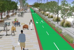
Normal Street Promenade Workshop - Thursday, January 24, 6:00 PM

The Normal Street Promenade will be a new public space in Hillcrest along Normal Street between University Avenue and Washington Street and will be the first transit-oriented pedestrian promenade in San Diego.
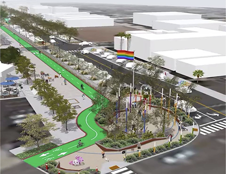 To develop the final concept, the City of San Diego and SANDAG will work with the community through a series of workshops. The conference room at Joyce Beers Community Hall will have different stations showing the bare bones concept and then a visual preference station showing options for lighting, landscaping, etc.
The first workshop will be held:
DATE: Thursday, January 24th
TIME: 6:00-9:00 p.m.
LOCATION: Joyce Beers Hall, 3900 Vermont St, San Diego
Please be sure to join fellow residents and learn more about this upcoming project. More background on our earlier report on the Normal Street Promenade here.
Park Boulevard Bikeway - open house & traffic safety hearing January 8
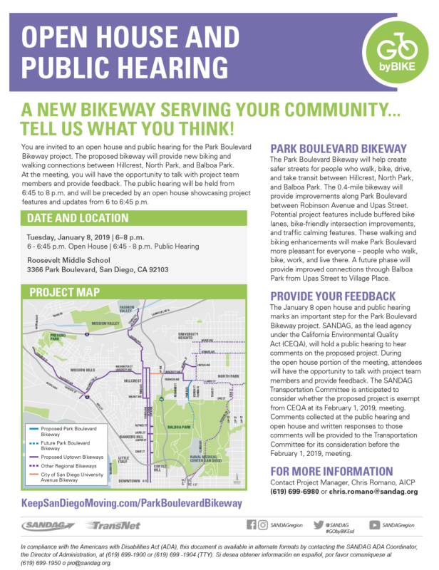 Mark your calendars for the January 8th open house and hearing about SANDAG's proposed Park Boulevard Bikeway Project. This event is focused on presenting the recently-completed Park Boulevard Traffic and Safety Impact Assessment.
Date/Time:
Tuesday, January 8, 2019
6 – 6:45 p.m. Open House
6:45 – 8 p.m. Public Hearing
Location:
Roosevelt Middle School
3366 Park Boulevard
San Diego, CA 92103
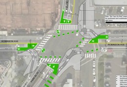
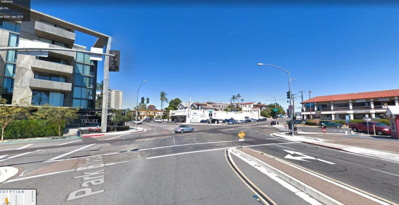
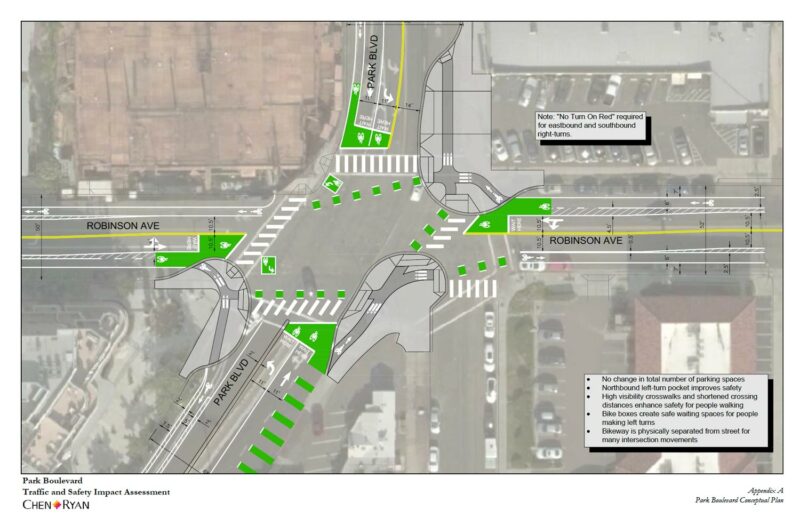
The Traffic and Safety Impact Assessment being presented at the open house has some very interesting bike and pedestrian path designs. Below is an image of the current intersection at Park Blvd. and Robinson Ave. Below that is a drawing from the Traffic Study showing how the new bike path is configured at this same intersection. The proposed bike lanes come up onto the corner bulb-outs and cross through the pedestrian space (taking the rider out of traffic lanes for many movements through the intersection). Please take a look at the Traffic and Safety Impact Assessment for more eye-opening details on this new bikeway.
SANDAG's Transportation Committee is anticipated to consider whether the proposed project is exempt from CEQA at its February 1, 2019, meeting. Comments collected at this public hearing and open house (as well as written responses to those comments) will be provided to the Transportation Committee for its consideration before its February 1, 2019, meeting.
SANDAG's project director believes the Park Boulevard bikeway has broad community support and doesn't expect much, if any, opposition to the design. Nevertheless, we encourage all BikeSD members with an interest in the Park Blvd bikeway to attend and give their input. Support for bikeways in San Diego is never something to be taken for granted so it's important for bike advocates to speak in favor of these facilities at every public hearing.
Hope to see you there on Tuesday at 6 pm!
SANDAG 2019 Regional Plan Transportation Themes Open Houses

SANDAG is in the process of developing San Diego Forward: The 2019-2050 Regional Plan, which will outline the overarching vision for our region over the next 30 years. As part of this process, SANDAG is asking for your input on what you think the San Diego region’s transportation network should look like in the future and what transportation issues are most important for your quality of life. This survey is available through May 10.
TAKE THE SURVEY
You will have to write in BICYCLE many times on the survey questions. For example, to answer the question "What method(s) of transportation do you use during your daily commute? (Select all that apply.)," Walking and Biking are listed together under Active Transportation. Walking and Biking are transportation modes that use different infrastructure. Biking should be its own method of transportation, particularly with such an extensive list that, for example, separates Carpool and Vanpool and has separate categories for Bus and Rapid. There are three comment areas on the survey to comment and reiterate that bicycling is extremely important. Let’s make our voices heard.
There are several workshops scheduled, during which, SANDAG employees are available to answer questions at multiple poster stations. The graphics are highly engaging, but the content is generalized and informational and avoids serious discussions regarding Climate Action Plan or Vision Zero goals. Here is the schedule for the upcoming workshops:
North County Coastal: Wednesday, April 25 from 5:30-7:30 p.m. Encinitas Public Library Community Room | 540 Cornish Drive, Encinitas 92024
East County: Monday, April 30 from 3:30–5:30 p.m. El Cajon Police Department Community Room | 100 Civic Center Way, El Cajon 92020
South County: Tuesday, May 1 from 5–7 p.m. San Ysidro Civic Center | 212 W. Park Avenue, San Diego 92173
North County Inland: Wednesday, May 2 from 5–7 p.m. Centro Universidad Popular | 1234 N. Santa Fe Ave, Suite 100 Vista 92083
Central San Diego: Thursday, May 3 from 5:30–7:30 p.m. Jackie Robinson Family YMCA Community Room | 151 YMCA Way, San Diego 92102
CLICK HERE for supporting materials for the workshops.
I attended the last workshop and here are a some of my comments on the information stations:
Emerging Technologies
"Technology is evolving and has the potential to radically change our region’s transportation system." I am doubtful that technology will radically change the region’s transportation system away from a car-centric approach. Political will could radically change the system, but not technology. Additionally, there is some early research that indicates ride sharing services increase Vehicle Miles Traveled or VMT.
Regional Plan Overview
Overall the Transportation Themes lean heavily toward a continuing car-centric approach to transportation. The Regional Economic Prosperity Objective includes "investing in transportation projects that provide access for all communities to a variety of jobs with competitive wages." And the Policy Objectives for Environmental Stewardship include making "...transportation investments that result in cleaner air, environmental protection, conservation, efficiency, and sustainable living and address climate change." How do these two policies interact? How is success measured for these policies?
Climate Change and Environment
On the poster "Reducing Greenhouse Gas Emissions: Passenger Vehicles and Electricity," the regional plan calls for allocating funding to electric vehicle charging stations while the "Local Efforts" poster calls for promoting public transit access, active transportation, parking management, and complete streets.
What Do We Want to Promote?
What does “Promote” mean? I would like to see “allocate funding for public transit access, active transportation, and complete streets.” Throw out parking management which is a euphemism for “make parking easier”—which promotes driving.
Healthy Communities
This station explains all the benefits from Policies and Strategies if local jurisdictions invest in transportation infrastructure that maximizes public health benefits, social interaction, and community cohesion. The benefits are numerous for increased access to active transportation and public transit, and walkable and bikeable neighborhoods.
Performance Measures
"Performance Measures" are a series of questions in several categories. For example, "Innovative Mobility & Planning Goals" includes these three questions:
1. Is delay reduced?
2. Are more people walking, biking, using transit, and sharing rides?
3. Is the transportation system safer?
These are great questions, the key is how will they translate into performance measures? And how much money will be allocated to measuring the goals?
Please attend a workshop in your region or take the online survey and type BIKES!
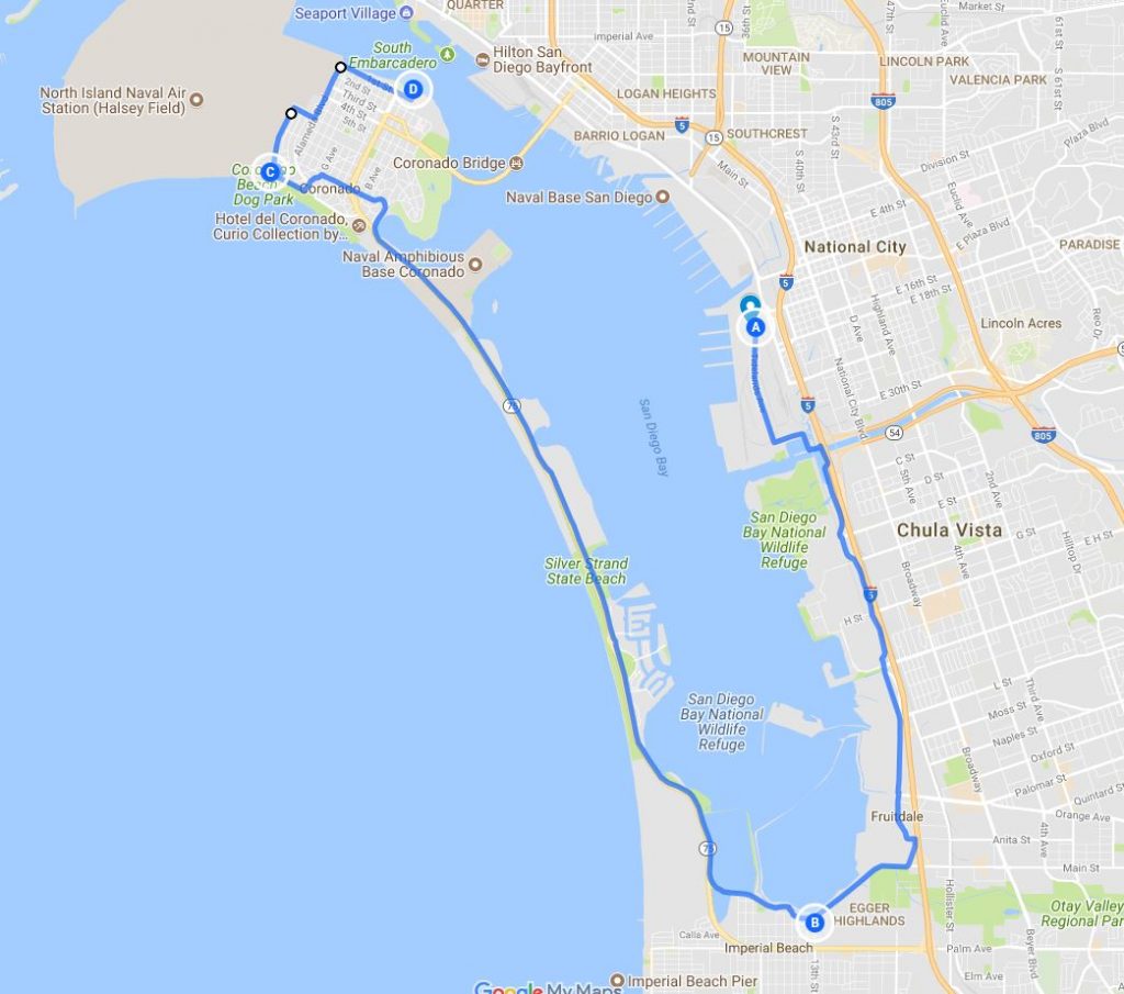
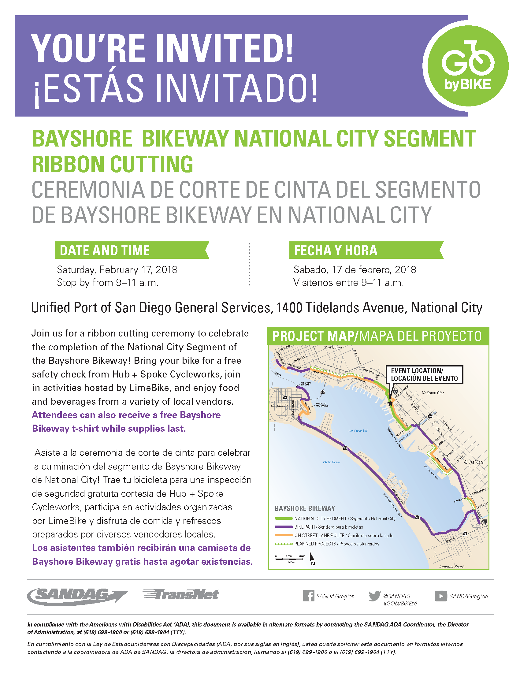
Join Us This Saturday (2/17) for a Bayshore Bikeway Group Ride and Ribbon Cutting!
This Saturday, 2/17, BikeSD will be joining SANDAG, elected leaders, and the public to celebrate the opening of an improved section of the Bayshore Bikeway in National City. It's great to see another portion of the Bayshore Bikeway get upgraded and we look forward to the completion of the full Bikeway, which was started in the 1970s. BikeSD will be present and sharing a table with our friends from the San Diego County Bicycle Coalition. We'll have our wonderful water bottles and terrific t-shirts for sale as well as flyers and stickers to give away and information for the public to get involved with BikeSD.
The ribbon cutting event starts at 9 AM at 1400 Tidelands Avenue, National City, CA 91950. The actual act of cutting will be at 9:30 AM with remarks and cheering. Come and enjoy the festivities with food and great local businesses like Hub + Spoke Cycleworks. After the ribbon cutting we'll be going on a group ride along the Bayshore Bikeway to Coronado with a stop at Trident Coffee in the recently opened Bikeway Village in Imperial Beach. We'll return on the Coronado Ferry which heads from Coronado to Downtown San Diego every half hour so we'll likely be on the 12:30 or 1:30 ferry. We'll start the group ride at 10:30 AM so please be there by 10:30 so we can all leave together.
Join us for conversation, enjoying the beautiful Pacific Ocean and San Diego Bay, and celebrating a step forward in creating a robust bike network across the City of San Diego and across the region. Below is a map of the route we'll take and after returning to Downtown San Diego we'll disperse or grab lunch, as people prefer. It will be a great start to the weekend and the ride is very flat and almost entirely on a dedicated bicycle path. Please join us and spread the word.
Here's the official flyer for the event as well.
See you Saturday morning and make sure to arrive by 10:30 AM to join us on the bicycle ride!