
News, Links, and Other Views
City of San Diego
-
Chopaderos One driver responsible for a hit-and-run in Hillcrest was arrested this past weekend.
- Council President Todd Gloria was on Fox News this morning talking the good word about facilitating bicycling and safe infrastructure. He said, in part, "right now I think that too San Diegans are forced to choose to commute only by car because they have no viable means of getting from A to B."
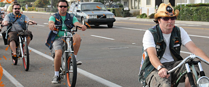
- From Juan Magdarog, news of San Diego's Outlaw Bicycle Club: Chopaderos.
San Diego Region
- A local cyclist, Mark Caporale, has established the Capo Community Cyclist Collective. Caporale writes, "I've begun a cyclist's collective in La Mesa to support and encourage my cycling friends and all who wish to ride more and ride well."
- KTU&A's Allson Moss writes about accommodating bicycle traffic around freeway interchanges.
- If you live in La Jolla and wanted to have an influence in making the community safer for all road users, sign up to fill one of the two vacancies currently open in the planning group.
National
- In news that should surprise no BikeSD supporter, Vox reports, "Driver error contributes to way more deaths than cyclist error". In further unsurprising news and why we don't support sharrow implementation on streets with more than one travel lane, the report goes on to state "Rear-end collisions cause a huge number of cyclist deaths" despite it being a small percentage of overall collisions.
- Marven Norman who presides over the Inland Empire Biking Alliance noted the unfortunate partner of DWB (Driving while black): WWB (Walking While Black) where drivers are less likely to yield to black pedestrians.
- The small town of Millbrae implemented a protected bike lane project at a transit station.
- In Idaho, a cyclist that survived a hit-and-run crash happens to be one of two pancreatic surgeons in the state of Idaho. Local police claim they are looking for the driver responsible for causing the injury.
- In Decobike news (from Miami), Craig Chester writes that "Bikesharing is good for taxpayers and the local economy".
- The invisible visible man documents his encounter with an entitled motorist.
- Strong Towns posts about signage failure.
Chip Sanders is on vacation.
For the Mid-City Community: Three Decades of Broken Promises

In late 1972, the California Department of Transportation (Caltrans) released a report detailing the impact that would result after the construction of I-15 (from I-805 to I-8, approximately 3 miles) through the heart of Mid-City, specifically the neighborhood of City Heights:
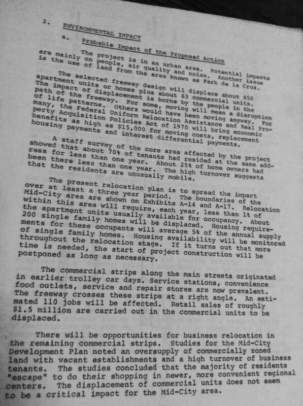
The project is in an urban area. Potential impacts are mainly on people, air quality and noise. Another issue is the use of land from the area known as Park de la Cruz.
The selected freeway design will displace about 650 apartment units or homes [Ed. note: displacing 2,000 people plus about 63 commercial units affecting 110 jobs and $1.5 million in annual taxable retail]. The impact of displacement is borne by the people in the path of the freeway. For some, moving will mean a disruption of life patterns. Others would have been moving away. For many, the Federal Uniform Relocation Assistance and Real Property Acquisition Policies Act of 1970 will bring economic benefits as high as $15,000 for moving costs, replacement housing payments and interest differential payments.
The report goes on to state:
The displacement of commercial units does not seem to be a critical impact for the Mid-City area.
Using logic that only a highway focused agency could come up with, the report goes on:
Exhaust emissions will be concentrated along the Route 15 corridor. Future traffic that would have used city streets or other highway routes will use the freeway. People working or residing along Route 15 will have better air quality after the freeway is constructed. However, this will be due to vehicle emission controls and the passage of time. It probably will not be due to the freeway.
Under the Federal Clean Air Amendments of 1970, the San Diego Air Basin will have to meet national ambient air quality standards by 1975. The freeway projects will not be completed in time to have any effect in meeting the 1975 deadline. By today's standards, 1975 and later vehicles will be essentially "pollution free". The number of pre-1975 models will decline with time; few will still be operating in 1986.
The report gets worse:
There will be noise impacts on the people remaining along the freeway corridor. From a community point of view, the freeway can probably be seen as a benefit. Noise levels at the closest homes will be lower than they are today. However, the people are not the same. Those living on the east side of Central Avenue, Terrace Drive and 39th Street will hear an adverse impact.
The destruction caused by the building of I-15 through City Heights may never fully be understood, but a documentary titled "The Price of Renewal" does give some light on the issue.
As depicted in The Price of Renewal, after the Caltrans announcement in the 1970s to build a freeway through City Heights, residents abandoned their homes and crimes began to rise contributing to a decline in overall quality of life.
Today, City Heights is finally turning a corner. After decades of advocacy by committed City Heights residents, the Centerline Bus Rapid Transit will finally be built (downgraded from a light rail line). Caltrans will finally be applying for funding to build the I-15 bike path from Adams Avenue to Camino del Rio South - fulfilling a promise made nearly three decades ago - that will connect the Mid-City Community to Mission Valley. And efforts are being made to eliminate the results of institutionalized neglect against a community made impoverished by former leaders too fixated on moving vehicles and building highways.

I do spend a considerable amount of time thinking about people like James D. Knochenhauer, the Regional Representative at the Bureau of Community Environmental Management, who in 1971 wrote a letter stating that the I-15 project wouldn't cause "any problems of health significance".
Today City Heights residents experience higher rates of asthma (than residents in the rest of the county) and a lack of access to transportation options despite only a third of the residents having access to an automobile.

I do wonder if individuals like Mr. Knochenhauer thought about the community of City Heights and how his letter of support contributed to decades of decline in a once vibrant and thriving community.
I wonder if he ever regretted writing that letter.
More on this topic here and here thanks to San Diego Free Press.
Morena Boulevard Station Study calls for improvements along Morena Boulevard
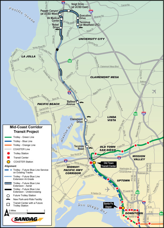
The Mid-Coast Light Rail Trolley is one of the transit projects proposed by SANDAG in their 2050 Regional Transportation Plan and is currently going through the planning and design phase:
The Mid-Coast Corridor Transit Project will extend Trolley service from Santa Fe Depot in Downtown San Diego to the University City community, serving major activity centers such as Old Town, the University of California, San Diego (UCSD), and Westfield UTC.
The project proposes station stops at Tecolote Road, Clairemont Drive, Balboa Avenue, Nobel Drive, Pepper Canyon, Voight Drive, Executive Drive, and Terminus Station.
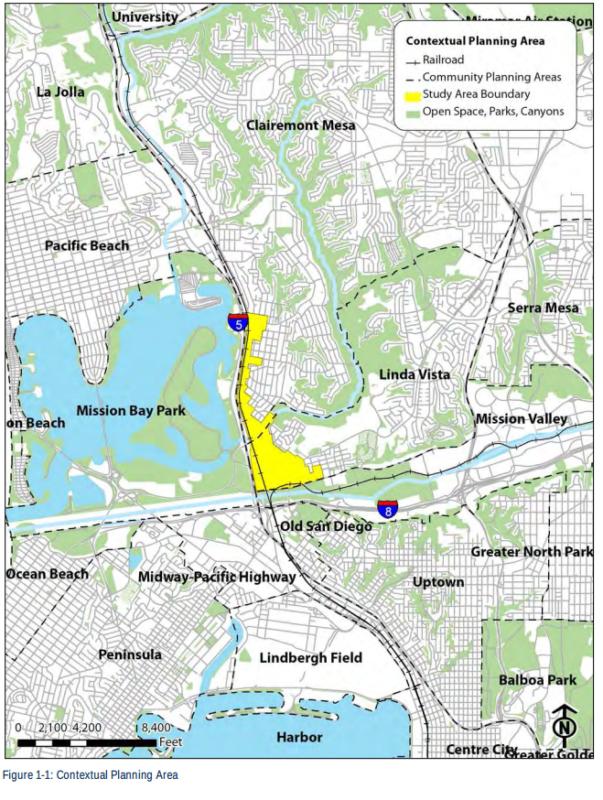
The Morena Boulevard Station Study covered the area that would include the stops at Tecolote Road (in the Linda Vista community) and Clairemont Drive (in the Clairemont community).
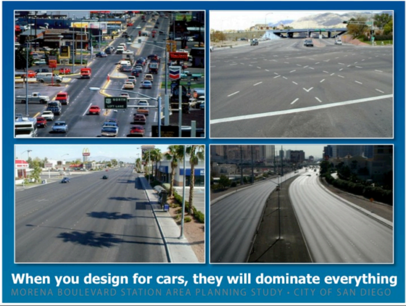
Included within the project's study scope was recommendations to improve mobility: bicycling and walking and removing focus from designing only for cars and instead designing for people.
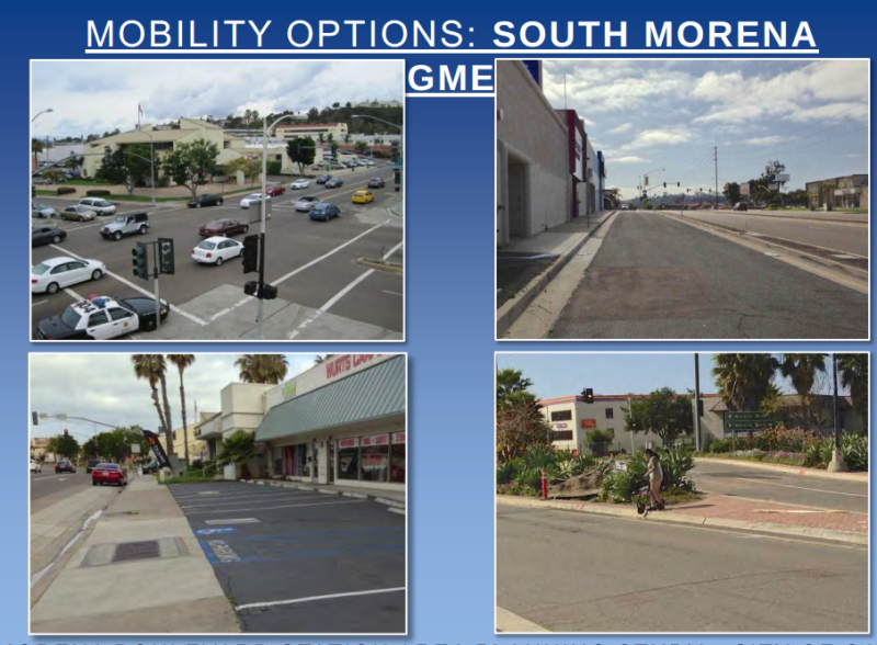
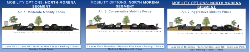
The mobility/transportation components broke Morena Boulevard into four segments: South Morena Boulevard, Tecolote Bridge, North Morena Boulevard, and Clairemont Bridge.
The year long community outreach process resulted in three alternatives which included good design proposals for safe and comfortable bicycling, Much thanks go out to our members Michael Muhammad (who until late last year served on the Clairemont Planning Group prior to moving to Long Beach, CA) and Kelly Cummings both of whom were instrumental in being a voice for safe and well designed bicycle facilities along Morena Boulevard as part of this process.
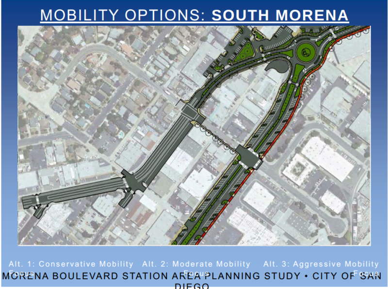
Below are the alternatives proposed for South Morena Boulevard. The alternatives were labelled: moderate, conservative, and aggressive.
Here is what South Morena looks like today:
This was a design proposed for safe bicycling on South Morena in the future.
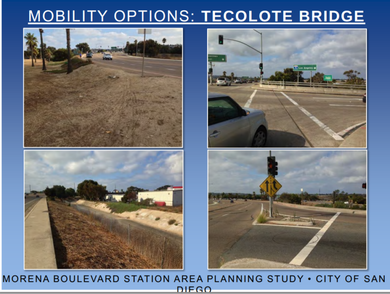
Today Tecolote Bridge looks like this:
In the future, Tecolote Bridge could look like this:

Today North Morena Boulevard looks like this:
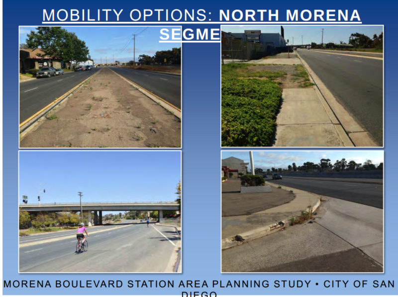
In the future, North Morena could like this:
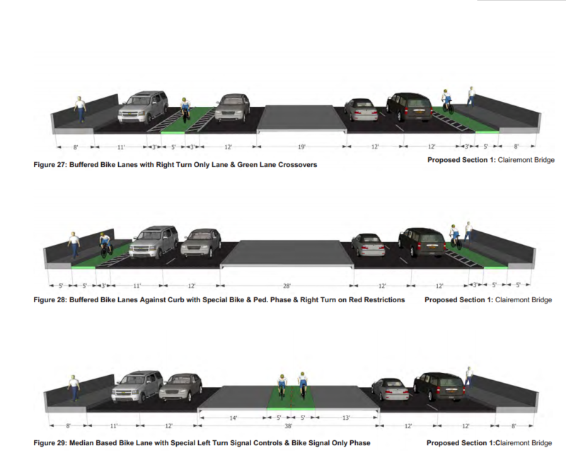
Today Clairemont Drive at Morena Boulevard has a lot of challenges as noted in the proposed plan:
The recommended solution for the Clairemont bridge crossing plan must address the existing issues that make it difficult for pedestrians and cyclists to mix with vehicles on the freeway overpass. The proposed solutions strive to improve the overpasses by providing facilities that buffer and protect pedestrians and cyclists while maintaining efficient vehicular traffic flow. Additional improvements are also included at the East Mission Bay Drive intersection with Clairemont Drive to provide better connections to the existing trail system around East Mission Bay.
If the design solution for the centerlane cycletrack sounds a little familiar, it is not unlike what was proposed here for Balboa Avenue by Michael Sullivan.
In the future, the Clairemont Bridge could look like any one of these solutions:
In addition to the bike improvements to improve mobility, the focus of the study was also around increasing population density along the transit corridors. This has resulted in some vocal opposition, the subject for a future post.
This Sunday: a Walking/Biking Tour of Uptown
Join me on a walking and biking tour of Uptown this Sunday starting at 10 AM. We will meet at the Joyce Beers Community Center (by the Trader Joe's).
Vehicle parking in Uptown tends to be tough, so I encourage you to walk, bike or take the bus to avoid an early Sunday morning stressful situation.
What's the purpose of tour? For the first time in San Diego's history, an investment of over $43 million will be made in the Uptown neighborhoods to make riding a bicycle safe and comfortable for all ages while simultaneously improving safety for all users including pedestrians and drivers. Yet, the community isn't overwhelming supportive of this project. Questions range from wanting Washington Avenue or Robinson Avenue to be the preferred East/West route to, wanting no vehicle curbside parking to be moved to, expressing a whole host of other concerns which have been addressed.
Despite the nearly two year long community outreach process by SANDAG - there still seems to be a lot of misinformation and questions, so I will be hosting a walking and biking tour of Uptown to discuss those concerns. I encourage you to bring your bicycle so that you can experience what it is like to walk and bike along the corridors that are part of the Uptown project and learn specifically why we have been advocating for University Avenue as the preferred east/west alignment in Uptown instead of Robinson Avenue or Washington Avenue. In an ideal universe, all three of these streets would be made safe but since SANDAG is busy funding freeway projects, funds available for making bicycling safe on all streets is not quite the SANDAG priority, yet.
I gave a short talk at the Hillcrest Town Council this past Tuesday and I asked the audience to describe what they thought a "cyclist" was. The response was not unlike what is brilliantly illustrated in this cartoon. I sensed a fundamental lack of relatability by many of the attendees at the Hillcrest Town Council meeting. The attitude, as I gathered, was that someone on a bicycle should take a circuitous route to get through and to Uptown rather than utilize the most vibrant street that exists: University Avenue.
But people are already riding on University Avenue. I have taken a few photos to showcase who rides University Avenue today. Don't you care enough to make it safe for them?


If you care about making University Avenue a safe place for everyone even our two-wheeled friends, then join this Facebook group that is all about promoting University Avenue and making it a safe place to ride a bicycle and walk without dying.
A Nightmare in San Diego: The I-805 Project
The 2050 Regional Transportation Plan is supposed to be a vision for San Diego's future. The introduction of the RTP has gems like this:
The 2050 Regional Transportation Plan (RTP or the Plan) is the blueprint for a regional transportation system that further enhances our quality of life, promotes sustainability, and offers more mobility options for people and goods.
And this:
The Plan envisions most of these new jobs and homes situated in environmentally sustainable communities that are more conducive to walking and bicycling. They also will have more access to public transit.
Yet, the entire basis of the plan's implementation is based on improving (vehicular) Level of Service which is painfully evident if you review how the region is expected to look after the RTP's implementation in 2050 (pink arrows are my markings noting where funds will be expended to alleviate vehicle congestion). To recap, Level of Service measures vehicular delay at intersections.

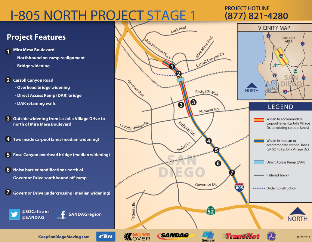
One of the projects listed in the 2050 RTP is the I-805 project and we're going to take a good look at the northern section of this project: all 11 miles of it that is expected to cost $587 million. That is a cost of $53.36 million dollars per mile. This cost includes design and construction of the project (but not maintenance).
But what is the project going to deliver?
The project will widen the freeway to accommodate four carpool, or High Occupancy Vehicle (HOV), lanes from SR 52 to La Jolla Village Drive and two carpool lanes from La Jolla Village Drive to just north of Mira Mesa Boulevard.
Additionally, the project will construct Direct Access Ramps (DAR) at Nobel Drive and Carroll Canyon Road to allow commuters to easily access the carpool lanes.
At the southwest corner of I-805 and Nobel Drive, a Park & Ride lot will be constructed to encourage carpooling and to provide bus transfers from the proposed Bus Rapid Transit facility.
The project also reconfigures the Governor Drive interchange by relocating the southbound entrance-ramp to the northwest quadrant. This would minimize the conflict with southbound I-805 traffic getting on SR 52. Lastly, the project includes a direct freeway-to-freeway HOV connector in the median, from westbound SR 52 to northbound I-805 and southbound I-805 to eastbound SR 52.
Notice that the description makes no mention of how someone on foot or on bicycle is expected to navigate around this new monstrosity. As part of the environmental review process, the project considered three alternatives:
2. Transportation System Management (TSM) and Transportation Demand Management (TDM) Alternatives, or another way to say, "accommodating drivers and driving".
3. No build alternative, which was immediately dismissed because "it would be inconsistent with the purpose and need of this project"
And what is the purpose of this project?
The overall purpose of this project is to provide a backbone of multi-modal transportation facilities for the I-805 North project area while providing safe and efficient regional movement of people and goods through design year 2030.
Or to put it another way, "multi-modal" meaning absolutely the opposite of that.
SANDAG unveiled a video seven months ago to offer an explanation of sorts on what the I-805 North Project was about, as explained by Gustavo Dallarda, Caltrans I-805/I-15/SR78 Corridor Director:
In short, Dallarda doesn't understand the fundamentals of how to ease congestion. SANDAG who is funding the project simply assumes that the only way to solve San Diego's traffic congestion woes is to widen roads and build additional lanes instead of providing sustainable or environmentally proven and sound transportation options. Despite Dallarda's half nod to the project facilitating other modes of transportation besides the automobile - such as the Bus Rapid Transit that is scheduled to be built well after the automobiles have been accommodated - the project falls far short of any of the ideals described in the SANDAG RTP. And with the addition of even wider ramps that someone on a bicycle will have to navigate past speeding vehicles, what we're looking at is the creation of a San Diego neighborhood that is going to be extremely unpleasant to be in.
In other words, SANDAG is funding a project that is contrary to the trends in this country.
What would it take for SANDAG to learn that roads cause congestion, and that the building of more roads is only going to exacerbate the problem?
The I-805 North Project doesn't go into the detail of how unbelievably unfriendly the project currently is to experience on a human level, and how much worse it is going to be.
The construction of the project has been going on for a little over a year now and the construction has made the situation in Mira Mesa awful, as narrated by Elaine Litchfield in the videos below:
The I-805 North Project lists among its features all the widening that is going to take place.
Litchfield and her husband live in Mira Mesa because she likes the neighborhood and her husband is able to take a BRT to his downtown job from a bus stop in front of their home. Her job is close enough that she can bike or walk to it - if it wasn't so terrifying.
When SANDAG began the visioning process for the RTP, the narrator explained that, "for the first time our planning efforts must focus on how to reduce greenhouse gas emissions."
Did SANDAG and the project's lead agency, Caltrans, really evaluate all options prior to deciding to go through with this project? How is expanding the road capacity for a 11 mile stretch to the tune of $587 million going to alleviate traffic congestion along the entire corridor? How is building this project going to make the community a place that residents will want to live in? Who is going to pay for the maintenance of this project and how will those funds be raised? And most importantly, how is this project sustainable or even vaguely environmentally friendly?
To provide perspective on how better these funds could have been spent, the city of Denver unveiled a 12.1 mile light rail line last April that was built using sales tax revenue and cost $707 million dollars.
Wouldn't a light rail be a better way to spend that $587 million to alleviate traffic congestion in San Diego?