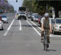
Photo by Adrian Granda of the buffered bike lane that currently ends at Laurel St.
Next Monday at 6:30 PM, the city will be presenting a plan to extend the new 4th and 5th bike lanes from Laurel Street. If you live or travel through Bankers Hill you should be there. Brian Genovese (City Engineer) is presenting 4th and 5th Avenue bike lane extension through Bankers Hill at:
3030 Front Street (Bankers Hill Social Club) on Monday at 6:30 PM (October 20th).
Opponents (such as Uptown Chair Leo Wilson – whom we’ve asked to step down as Chair) are claiming that the city needs to do a environmental analysis in order to add a bike lane. In an email sent earlier this week, Wilson writes:
Attached is a copy of the San Diego Bicycle Plan. Page 138 has the bicycle plan's recommendations for 4th and 5th Avenues in Bankers Hill.
The recommendations are for Class II and Class III bicycles lanes -- not a Class I type of bike route that would require the removal of traffic lanes. Instead the bicycle plan (p. 138) indicates it "would be necessary to narrow the existing traffic lanes to 11 feet and narrow the existing parking lane to 7 feet to provide necessary space for Class II bike facilities along 4th and 5th Avenues." It does not recommend lane reductions
The City's claim they can remove traffic lanes based on the recommendations of the City's approved bicycle master plan are erroneous. There needs to be CEQA review, and an amendment to the bicycle plan involving a community review process.
That's right. San Diego has its own Rob Anderson and his name is Leo Wilson.
Making room for a bike lane by reducing and existing travel lane doesn't result in a Class I bike path (examples being the Harbor Drive multi-use path or the Bayshore Bikeway). If anything, narrowing existing travel lanes will result in the city creating a Class II bike lane (marked by paint stripes on asphalt with painted buffer hatch marks). With some sustained effort, our advocacy will result in eventually converting that Class II bike lane into a cycletrack or a Class IV facility, recently approved by the Governor, thanks to the California Bicycle Coalition.
As an update to the petition calling for Leo Wilson to step down as chair to the Uptown Planners I asked Marlon Pangilinan, a city planner who oversees Uptown, a few questions and he provided me with some clarification on the rules about Community Planning Group members. The responses are below:
1. Are there rules on how long a member of a planning group can serve both on the board and as chair?
Yes. According to Council Policy 600-24 which provides the standard operating procedures and responsibilities for the City’s recognized Community Planning Groups (CPG), no person may serve on a planning group for more than eight consecutive years if members are elected to two- or four-year terms, or nine consecutive years if members are elected to three-year terms.
The eight or nine year limit refers to total service time, not to individual seats held. After a one-year break in service as a planning group member, an individual who had served for eight or nine consecutive years shall again be eligible for election to the committee. There are exceptions to serving more than the 8 to 9 year limit in the case there are not enough members to fill vacant seats.
In the case of the Uptown Planners, their approved bylaws dictate fixed terms of 4 years, therefore the maximum time an individual can serve on the Uptown Planners is 8 years.
The Chair is an officer position on the Uptown Planners. The length of the officer’s term is one year. However, officers are elected annually from the and by the members of the Uptown Planners, so the same individual can be voted to fill the same officer position every year except that no person may serve in the same Uptown Planners office position for than 8 consecutive years.
2. What are the consequences for violation if there are rules?
If a violation is proven, the CPG must take corrective action. A planning group member or planning group found to be out of compliance with the provisions of Council Policy 600-24, or the planning group’s adopted bylaws, risks loss of indemnification (legal protection and representation) and forfeiture of its status as recognized advisory body.
3. Has there been an effort to unseat a Planning Group chair in the past? What has the result been?
No. Based on my recent discussions with other Community Planners in the Planning Department, there have been complaints regarding the way CPG Chairs run the meetings and regarding Chairs with perceived conflicts of interest, but with no apparent or proven violations.
Hope to see you on Monday at 6:30 PM. We could sure use your presence.
Update: John Anderson has a great writeup of the meeting.
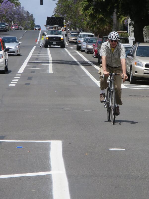
Wide roads induce high speeds which creates dangerous conditions for all road users. Visual via Transit Miami
One Paseo is described by One Paseo's website as a "proposed neighborhood village to live, work and play in the heart of Carmel Valley"
One Paseo is a proposed mixed-use development that (if approved as proposed) will be built in Carmel Valley in a currently mostly vacant lot that sits beside Del Mar Heights Road between El Camino Real and High Bluff Drive.
The project's website states the following (among other things):
"Cycle tracks, the first of its kind in San Diego, will be lined around this gateway road, one of the most utilized streets in Carmel Valley."
First, a correction. The claim that the proposed 0.3 mile cycletrack along Del Mar Heights Road in front of the One Paseo project would be the first of its kind in San Diego is incorrect. Friars Road has had a cycletrack, if a bit ill-maintained, for decades (on the southside between Sea World Drive and Fashion Valley Road). The other cycletrack on Sea World Drive has been in existence for at least one decade, thus the cycletrack along One Paseo will not be the city's first.
Fact: Bicycling to One Paseo is also discouraged by the high volume, high speed 6 lane roads that bicycles must navigate. Even though bicycle lanes are provided, only the most experienced cyclists would brave these conditions. Would you let your children ride on these roads?
Del Mar Heights Road is generally an east-west trending roadway within the study area (Mango Drive to Carmel Canyon Road). Between Mango Drive and Portofino Drive, it has a functional classification of a five-lane major roadway. From Portofino Drive to the I-5 northbound (NB) ramps, it has a functional classification of a five-lane prime arterial, and a six-lane major roadway between the I-5 NB ramps to High Bluff Drive. From High Bluff Drive to Carmel Canyon Road, Del Mar Heights is functionally and ultimately classified as a six-lane prime arterial. The roadway width within the traffic study area is 102 feet and the posted speed limit is 40 mph. No parking is allowed along this section of the roadway. Class II bike lanes 1 are located along both sides of the road.
Because the project will have an impact on the surrounding environment and significant and unavoidable impacts will remain even after mitigation efforts, a Statement of Overriding Considerations was prepared. This document calls for the creation of three left turn lanes and the widening of Del Mar Heights Road:
In addition, at the intersection of Del Mar Heights Road and High Bluff Drive, prior to the issuance of the first certificate of occupancy for Phase 2, the applicant must (1) widen Del Mar Heights Road on the north side receiving lanes,re-stripe the northbound, left-turn lane, re-phase the signal to provide northbound triple left-turn lanes, and modify the eastbound and westbound left-turn lanes to dual left-turn lanes; and(2) widen the eastbound approach by 2 feet on the south side to accommodate the eastbound and westbound dual left-turn lanes (MM 5.2-7).
One of the first major efforts we undertook after we launched as an advocacy organization two years ago was to advocate for narrowing the travel lane on Montezuma Road after Chuck Gilbreth was killed. Our reasoning then (as it is now) is that wide roads induce high vehicle speeds which makes bicycling (and walking) conditions dangerous. This is substantiated with research and data from government agencies, transportation researchers and more.
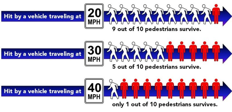
Motor vehicle crashes, which are the leading cause of unintentional injury deaths in the United States each year, killed over 30,000 people in 2010. Vehicle speed is a major factor in many of these collisions, and higher speeds are especially dangerous for pedestrians and cyclists when collisions occur.
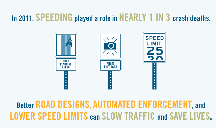
Multiple factors contribute to the problem of unsafe traffic speed. Among the most common are road designs that encourage higher speeds, speed limits tha tare set too high, and speeding (people driving faster than the speed limit or too fast for road conditions). Speeding is the most studied of the three factors.
Police reports indicate that speeding played a role in nearly 1 in 3 crash deaths (9,944 people in 2011). In fact,almost 9 out of 10 speeding-related deaths took place on non-Interstate highways, most of which have speed limits of 55 mph or less.
Small traffic speed reductions can lead to fewer motor vehicle crashes, injuries, and deaths. Slower speeds may also promote physical activity by making roads safer and more inviting for pedestrians and cyclists —especially when combined with specific road features for those users. Proven measures exist to reduce vehicle speeds to levels that are safer for everyone on the road
But One Paseo calls for widening the already wide road while simultaneous calling the project walkable/transit friendly and bikeable.
But here in San Diego, city staff recommended the project be approved by the Planning Commission. The One Paseo project was endorsed by the Move Alliance and by the San Diego County Bicycle Coalition, among others.
If you are horrified at the thought of San Diego widening on our already wide roads while relying on Level of Service as a metric of environmental impact (despite being dead to the state), I'd encourage you to consider emailing the Planning Commission at: planningcommission@sandiego.gov. The Commissioners are scheduled to continue their deliberations this Thursday and will vote on the project. If they support it, it will go on to City Council for the final vote.
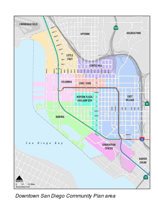
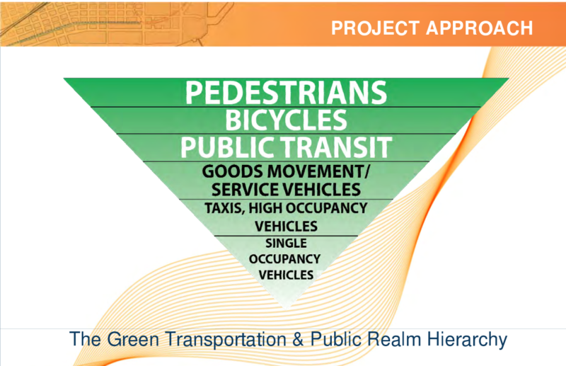
Nothing showcases the plan to prioritize people over motor vehicles better than the visual above. This exciting approach (for San Diego) is part of Civic San Diego's plan to transform downtown San Diego, and do so quickly. And it's all part of a plan that is being worked on called the Downtown Mobility Plan.
Civic San Diego is not afraid to dream big, and tonight they are hosting the second of three workshops to determine the public's preferred network of corridors for pedestrians, bicycles and autos for Downtown San Diego. How is all this being funded? Through SANDAG's Active Transportation Program and the Downtown Parking District.
Join Us at Community Workshop #2
Tuesday, October 7, 2014
6pm – 8pm
Civic San Diego Board Room
401 B Street, Fourth Floor
San Diego, CA 92101
(RSVP here)
The Downtown San Diego Mobility Plan will establish policies, programs and projects that will improve overall mobility throughout the Downtown San Diego area. The Mobility Plan will provide for the development of a balanced and cohesive network of complete streets, which will increase priority and safety for bicyclists and pedestrians, provide desirable connections for all users to key destinations, and support reductions in greenhouse gas emissions.
If you can't make it out in person, why not complete this questionaire to state your preferences and vision for downtown?
Covering approximately 1,450 acres, the plan area’s population of approximately 37,000 is anticipated to grow to 90,000 residents by 2035. Presently, 75,000 people work downtown and it is projected that by 2030 the workforce population could increase to 168,000.
But who or what is Civic San Diego?
Civic San Diego ("CivicSD") is a public non-profit corporation, which,among other functions, provides planning services to the City of San Diego in the Downtown Community Plan area.
The colored area of the map represents downtown.
From the overview, the mobility plan will provide for the development of a cohesive network of complete streets, which will:
increase priority and safety for bicyclists and pedestrians by providing supportive facilities and amenities;
provide desirable connections for all users to public parks, main shopping areas, entertainment facilities, major attractions, the waterfront, surrounding communities, and the regional transportation network; and
support reductions in greenhouse gas emissions.
The goal is to have this plan adopted by City Council by next May and get right to implementation. It is refreshing to see such change happen quickly in San Diego.
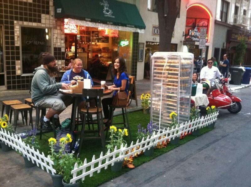
While San Diego continues to pave over and give away public land to store private vehicles, some San Diegans continue their determined focus to call attention for the need for more open space. Tomorrow is Park(ing) Day, the annual event that creates temporary urban havens for people. The original thought behind Park(ing) Day was as follows:
The mission of PARK(ing) Day is to call attention to the need for more urban open space, to generate critical debate around how public space is created and allocated, and to improve the quality of urban human habitat … at least until the meter runs out!
Downtown Partnership has outdone itself with the sheer number of locations that will have temporary parklets instead of parking spaces tomorrow.
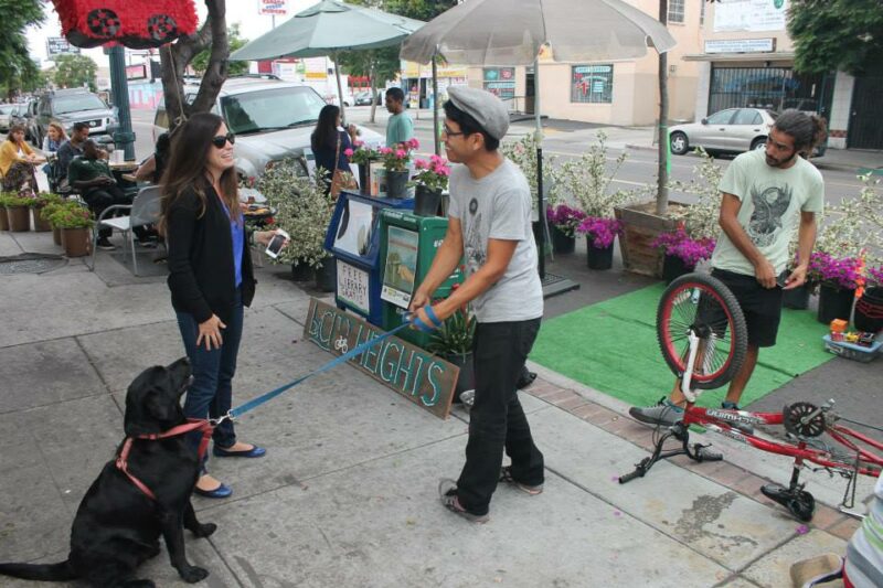
Cherokee Point resident Vince Rivera chats with one of the family members who owns Super Cocina at Park(ing) Day 2013. Photo: City Heights CDC
In Mid-City, the bicycle and pedestrian planning company, KTU&A is hosting a Park(ing) Day Pit Stop featuring a cycle-track exhibit from 8-10 AM at Normal St and Harvey Milk St. The City Heights CDC is hosting a Park(ing) Day in front of Super Cocina at 3627 University Avenue.
But temporary parklets are a thing of the past. thanks in part to the strong efforts of Elizabeth Studebaker who works in the city's Economic Development Department. Right now, construction is underway for four bike corrals at:
South Park – Mythology, 2365 30th Street
North Park – Modern Times Brewing, 4026 30th Street
El Cajon Blvd – Live Wire & Mama’s Lebanese Bakery, 4237 Alabama Street
Hillcrest – Lotus Thai/Jake’s on 6th, at 3761 6th Avenue
Construction is also underway for the creation of parklets such at the one at Alabama Street:
It seems like a lifetime ago when the temporary parklet at 30th and Upas made its appearance back in 2012.
2012: A makeshift Parklet created on Park(ing) Day in front of Sea Rocket Bistro. Photo: Dennis Stein, co-owner of Sea Rocket Bistro.
Maybe all those parking spots are future bike corral and parklet venues.
Reading about the 1975 Regional Transportation Plan, the region's first comprehensive plan to guide the region's growth into the future, gives me a feeling that I'm living in a real life version of Groundhog Day - the 1993 movie about a man who finds himself in a time loop living the same day over and over again. It seems like portions of history are repeating itself again. And this provides a window of an opportunity to permanently change the course of our transportation future which is again within our grasp.
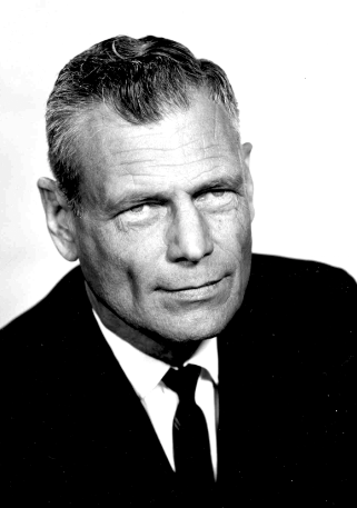
Jacob Dekema, First District of Caltrans' San Diego/Imperial County Office. Perhaps the most influential person in San Diego.
Understanding the reasons behind the failure of regional planning in the San Diego region requires some understanding of Caltrans' influence on the region alongside some understanding of state and bike advocacy politics.
In 1975, our current Governor, Jerry Brown, was first elected governor. He had appointed Adriana Gianturco as Director of Caltrans - to oversee the agency's operations throughout the state. But she wasn't well received. San Diego's first Caltrans District Director Jacob Dekema stated that Gianturco "was opposed to all highway construction. She wanted everybody to ride bicycles or streetcars or buses, and any highways would be over her dead body." Gianturco had no chance of success even with her approach to bicycling .
Four years prior to Gianturco's appointment, current Lemon Grove resident John Forester was ticketed in Palo Alto for riding on the street instead of on a separated bicycle facility. This ticket inspired him to spend the rest of his life (to this day) fighting any sort of bicycle facility while remaining curiously silent on the Caltrans' highway focused approach on the region and our local communities. Forester's persistence allowed him to successfully defeat any bicycle facility design guidelines at the state level. Today his followers consider Caltrans a worthwhile authority on bicycle facility design while more credible advocates continue to fight and wrest control away from Caltrans' influence on urban bicycle facility design standards.
In 1975, the Caltrans District Director overseeing San Diego, Imperial County and east Riverside County, Jacob Dekema, was firmly ensconced in his San Diego office determined to oversee the implementation of his visionary freeway network. While there is a temptation to compare Dekema with New York's Robert Moses, I'd venture to state that Moses' vision didn't go nearly as far as Dekema's vision to completely upend the urban fabric of San Diego's core urban neighborhoods. Not unlike Moses, Dekema had no interest in envisioning a San Diego that was truly multi-modal. Dekema's focus was on the motor vehicle and only the motor vehicle.
Dekema was in charge when SANDAG's predecesor, the CPO, adopted the first Regional Transportation Plan. The plan, a promise to the region was updated in 1976. Dekema received this update accompanied by a cover letter from the chairman of the CPO board, describing the plan as an "integrated, multimodal transportation plan prepared for the San Diego Region". The CPO board chair went on to state, that the plan "contains refined and updated policies, plans, and programs for maintaining and improving the transportation system over the next 5, 10, and 20 years."
The plan's failure, in retrospect, lied in its failure to quantify how success of the plan's implementation would be measured. There wasn't a way to ensure accountability to the public. There was no strategy within the plan to expand transportation choices or induce transportation mode shift.
However the plan itself was thorough. It addressed the region's transportation sector fairly comprehensively: freeways, transit, bicycle, commercial aviation, and maritime based on the needs and input captured at several public meetings.
In 2008, Voice of San Diego published a short writeup about this original vision of a strong urban transportation system that was adopted in 1975. Why wasn't this vision actually implemented? According to a former SANDAG rep, Garry Bonelli, it was due to local political leadership and insufficient public support failing to coalesce around a strong, urban transportation network:
“Where it fell short was on coalescing enough political and public support,” he said. “People were asking why should I spend that kind of tax money when I can get in my car and drive anywhere I want and get there in 10 or 15 minutes?”
I'd posit that it wasn't so much that local leaders and the general public that failed to support the vision stated within the 1975 plan. But rather, it was the institutional longevity of both SANDAG and Caltrans that surpassed any political tenureship and led to the failure of the regional plan's success.
Caltrans and SANDAG as institutions have lasted far longer than any administration or elected representative's tenure. Brown may be back in office to complete his unfinished work. But without significant change within the institutional govenmental agencies that affect our daily lives in silent and numerous ways, no good intention or plan can ever be fully realized. The SSTI report commissioned by Brown may be the first step that leads toward the reform of Caltrans. But in the meantime, we have Caltrans continuing to drive the discussion that is transportation in the region as evidenced with the recent I-5 widening approval. This $6.5 billion dollar plan was supported the topexecutives of SANDAG, who also just happen to be former Caltrans executives. Do the top executives of SANDAG want or even envision San Diego being a multi-modal region? Evidence from the I-5 decision points to, "no".

 Nothing showcases the plan to prioritize people over motor vehicles better than the visual above. This exciting approach (for San Diego) is part of Civic San Diego's plan to transform downtown San Diego, and do so quickly. And it's all part of a plan that is being worked on called the Downtown Mobility Plan.