
MEDIA ADVISORY: Advocates Call on Mayor Faulconer and City of San Diego to Replace Painted Over Bike Lane After Hit & Run

FOR PLANNING PURPOSES: Wednesday, September 2, 2020 at 11 AM
MEDIA CONTACT: Kyle Heiskala
Phone: (619) 300-9484
Email: director@bikesd.org
M E D I A A D V I S O R Y
Advocates Call on Mayor Faulconer and City of San Diego to Replace Painted Over Bike Lane After Hit & Run
WHAT: Press conference with bicycle safety advocates to call on the City of San Diego and Mayor Faulconer to immediately address the dangerous situation on Washington Street and to replace a bike lane which was painted over to add parking. As a result of the existing unsafe conditions, a 66-year old bicyclist riding eastbound on Washington on August 21st, 2020 was struck by a car and critically injured and the driver fled the scene.
WHO: Bicycle Advocacy Organization Representatives
-
BikeSD
-
San Diego County Bicycle Coalition
-
San Diego Mountain Biking Association
WHEN: Wednesday, September 2, 2020, at 11:00 am
WHERE: 3754 Columbia St, San Diego, CA 92103 - Intersection of Columbia St and Andrews St
More information: The bike lane symbols formerly in this location were painted over to add free street parking. As a result, a 66-year old bicyclist riding eastbound on Washington on August 21st, 2020 was struck by a car and critically injured and the driver fled the scene. View SDPD video on Twitter here: https://twitter.com/SanDiegoPD/status/1297338194921320448?s=20
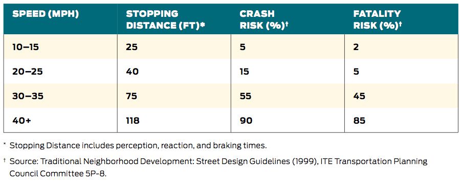
Last year, 44 pedestrians, bicyclists, and vehicle and motorcycle drivers lost their lives unnecessarily on San Diego streets and six bicyclists have been hit since 2012 near the Washington St and India St intersection. The current Class III painted “sharrows” in the second eastbound travel lane are not recommended by the State of California for speed limits above 35 MPH. However, the posted speed limit is 45 MPH, and a speed study of the corridor showed traffic speeds averaging 55 MPH or more, with some motorists traveling 70 MPH.
BikeSD https://bikesd.org/ | San Diego County Bicycle Coalition https://sdbikecoalition.org/
San Diego Mountain Biking Association https://sdmba.com/
###
DownloadLetter Sent to the Mayor to Support a Safe Bicycle Facility on Washington Street
Dear Mayor Kevin Faulconer & City Staff,
We request the City of San Diego immediately address the public safety hazard on eastbound Washington Street (east of India Street) by returning the Class II bicycle facility to the breakdown lane on the south side of the road. The bike lane symbols formerly in this location were painted over without City permission, to add free street parking. As a result, a 66-year old bicyclist riding eastbound on Washington on August 21st, 2020 was struck by a car and critically injured and the driver fled the scene.
This segment of Washington was identified by the City as a “High Priority Bicycle Project” in the 2013 Bicycle Master Plan, and is a designated City bike route. SANDAG also identified the Washington Street Bikeway in its 2012 Early Action Plan, but opposition to the Bikeway from local business districts necessitated costly studies and additions to the project, delaying Bikeway construction until 2022.
The current Class III painted “sharrows” in the second eastbound travel lane are not recommended by the State of California for speed limits above 35 MPH. However the posted speed limit is 45 MPH, and a speed study of the corridor showed traffic speeds averaging 55 MPH or more, with some motorists even exceeding 70 MPH. The City is forcing bicyclists into dangerous, high-speed traffic on a steep incline. Further, the City is not notifying motorists that the road contains a bike lane, as the signage that was posted on the hillside has been removed, and the street cycling symbol on the road has been painted over. Washington Street is the main connector to the Washington Street Trolley Station for residents of Mission Hills, Hillcrest and Bankers Hill. The City of San Diego’s requirement to reduce vehicle miles travelled, and its Climate Action Plan and Vision Zero goals are further reasons to address this corridor’s safety hazards, where six bicyclists have been hit since 2012.
We ask that the City prioritize residents’ lives and well-being over a dozen free parking spaces. Please restore the Washington Street bike lane until the completion of the SANDAG Washington Street Bikeway in this area.
Sincerely,

A Vision for Texas Street
By Nevo Magnezi, BikeSD Board Secretary
On August 18, 2019, Tom Morris, a man with a walker, was killed due to traffic violence while trying to cross Texas St in North Park. On November 17 of the same year, a 33-year old man was killed, also trying to cross Texas St, this time by a big rig truck. They join 6,590 other Americans who were killed in 2019, doing something that comes naturally to all of us: getting around on foot. Indeed, 2019 saw the highest pedestrian fatality rate in the United States since 1988.
Other cities in developed countries don’t seem to have this issue. Oslo and Helsinki saw zero pedestrian deaths in 2019. This success is not because our Nordic friends are less likely to jaywalk. Rather, it is because urban planners in those places design their built environment to be safer and more forgiving to human error. The tired excuses that San Diego is so distinct from other places that we must simply accept the killing of our community members cannot be tolerated. We can and must do better to make our entire transportation system safer.
So what makes Texas Street so deadly? Between wide streets, heavy traffic, insufficient pedestrian crossings, and a complete lack of any biking infrastructure, Texas Street is not designed for humans in mind.
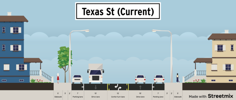
As city planners know well, speed kills. The National Association of City Transportation Officials, or NACTO, recommends that lane widths be 10 feet in urban areas to reinforce a 25mph speed limit, or 11 feet for designated bus and truck routes such as Texas St. The current distance from the edge of the street parked cars and the line delineating the center turn lane is 14 feet. The city must reinforce a design that truly limits vehicle speeds to 25mph, and that means ensuring lanes are only as wide as their intended use.
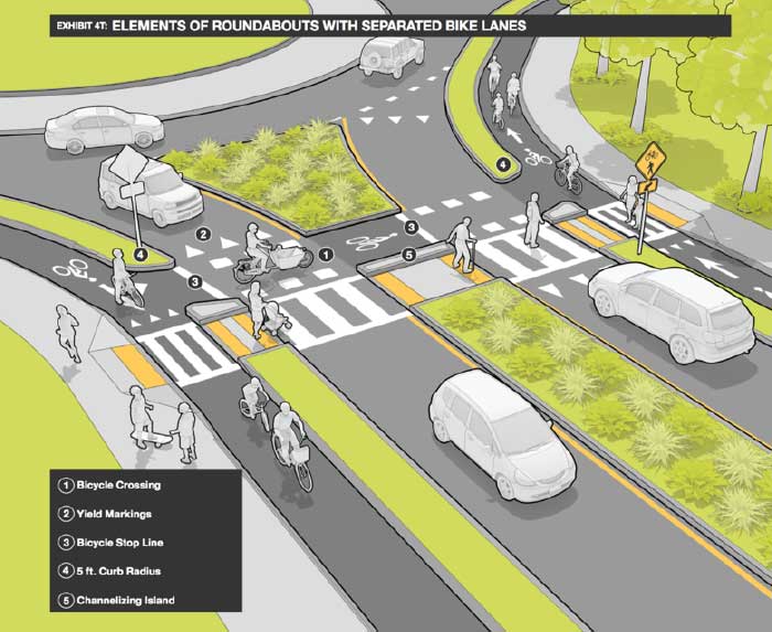
With two 11 foot vehicle lanes, the pedestrian crossing distance, should naturally be no more than 22 feet. By implementing mini-roundabouts, as done on Meade Ave, in conjunction with pedestrian refuge islands and curb extensions, the pedestrian crossing distance can be reduced to 11 feet at intersections. Furthermore, raised continental crosswalks implemented at every intersection could further increase the visibility of pedestrians and provide much needed mobility to disabled folks who currently cannot cross at many of the intersections.
With each vehicle lane width of 11 feet and 7-8 feet for street parking, that leaves 16 feet left on this 52 foot wide street. We believe that the best use of the remainder of the street width would be for two 8 foot wide cycletracks, including buffer, adjacent to the curb. Similar designs of sandwiching cycletracks between the sidewalk and street parking have successfully been implemented in many other cities as well as downtown. We note that the North Park Community plan calls for a class II bike lane facility, which makes sense, as in addition to being a bus, truck, vehicle, and pedestrian route between North Park and Mission Valley, Texas Street is also a bike route and has class II bike lanes north of Madison Avenue. That being said, we believe a class IV cycletrack is more appropriate for Texas street between Madison Avenue & University Ave because of the NACTO recommendation that streets with a speed of 25mph and an average daily traffic volume of greater than 6,000 vehicles be equipped with protected bike lanes, in order to become a facility suitable for all ages and abilities.
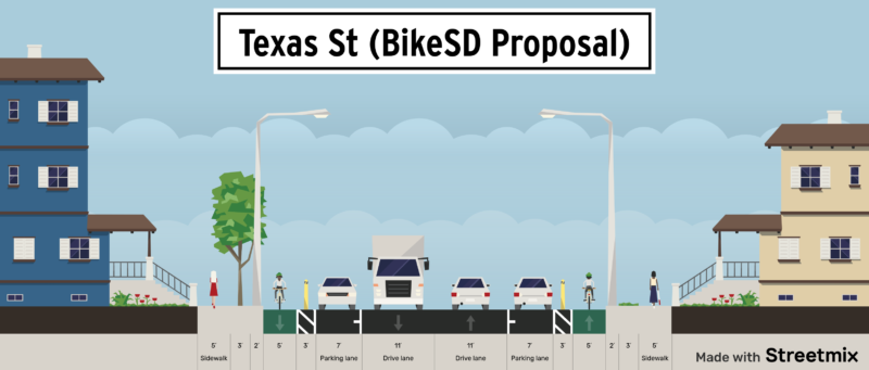
Finally, we would like to note that we think it would be great to keep the approximately 98 public street parking spaces, according to our count, on Texas St between Madison Avenue and El Cajon Boulevard, as well as points south. Parked cars can further provide protection and limit speeds by making the lane feel even narrower to drivers, and offer convenience to those who drive in the neighborhood. However, our top priorities must be satisfying our vision zero and climate action plan goals. Ultimately, we defer to the expertise of our city planners in determining how much street parking can be maintained.
No doubt, building roundabouts, protected bike lanes, and extending curbs will be costly. While BikeSD is not qualified in estimating the total cost, it is worth noting that in 2013, the state of California determined the economic loss associated with each traffic violence death to be 1.32 million dollars. With two deaths and twenty five reported injuries since the beginning of 2018, building a safer Texas Street will be a steal in comparison to doing nothing. The state provides funding for jurisdictions to build complete streets through SB-1, however so far the city has not used any of that money explicitly for that purpose. We ask that the City of San Diego use all available funding sources, including SB-1, in order to ensure that Texas Street becomes safe for users of all ages and abilities.

Letter to the Mayor re: District 2 Recommendations for Transportation Actions as COVID-19 Response
“Given the emergency physical distancing requirement, coupled with fewer cars on our roads, we need to acknowledge that people will be outdoors for a little personal exercise, and our responsibility is to make sure that it happens in as safe a manner as possible,” said Councilmember Dan Kalb, chair of the City’s Public Works Committee.The City of Oakland will work closely with neighborhood residents and community organizations to install signs and temporary barricades along Oakland Slow Streets and at key intersections. Residents will also be encouraged to print Oakland Slow Street signs and post them in their neighborhoods.
-
Mission Blvd from Pacific Beach Drive to South Mission
-
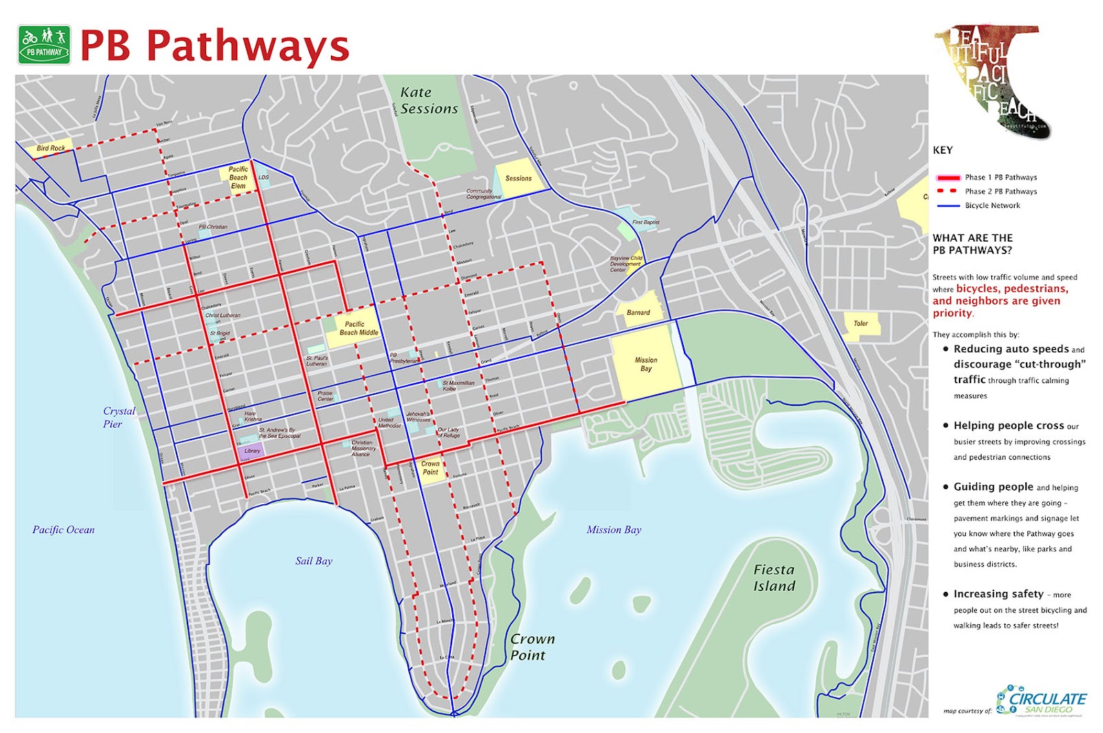
PB Pathways: Phase 1 and 2 (See attached map.)
-
Sunset Cliffs Blvd and Cordova Street south of Point Loma Blvd. (This will drastically improve the safety concerns of overcrowding on the cliffs.)
-
Bacon Street from Robb Field to Del Monte
-
Brighton Street from Spray Street to Guizot Street
-
Evergreen Street from Nimitz to Talbot
-
Mission Blvd from Law Street to Pacific Beach Drive
-
West Point Loma Blvd. from Nimitz to Sports Arena
-
Midway Drive
-
Morena Blvd
-
East Mission Bay Drive and Mission Bay Drive
-
Mission Blvd from Pacific Beach Drive to South Mission (This would be an addition or alternative to the above recommendation. Provide a secured parking lot for residents to use if residents have parking issues.)
-
The north-south bike path on the eastern edge of Robb Field and the car travel lane out to West Point Loma Blvd. (Currently, active commuters have no safe access out of OB.)
-
Old Sea World Drive (Restrict vehicles but allow active commuters.)
Letter to the Mayor re: Recommendations for Active Transportation Actions as COVID-19 Response
BikeSD sent the following letter to the Mayor and City Council of San Diego in coordination with several other advocacy & community organizations.
---
Dear Mayor Faulconer,
On behalf of the undersigned transportation and community-based organizations, we are writing with recommendations for how to address the public health crisis resulting from the COVID-19 pandemic through addressing transportation needs. Our recommendations aim to aid essential travel needs for individuals and household units and relieve pressure from overcrowded sidewalks; in no way do we aim to encourage group activities with these recommendations.
Based on the need to allow for safe physical distancing of at least six feet to reduce the risk of transmission, we recommend the following immediate actions be taken:
- Modify Pedestrian Signal Activation - Most streets with pedestrian crossing buttons require that they be pushed to change the light and activate the walk sign. Some streets provide more time to cross the street safely when the pedestrian crosswalk button is activated. Yet no one should need to push a button – and risk spreading the virus – to cross the street safely during this pandemic.Pedestrian crosswalk buttons should be switched to automatically provide the walk sign to a pedestrian without having to press it, citywide.
- Prioritize Pedestrian and Bicyclist Safe Travel on Crowded Corridors - People are walking and cycling, either for essential travel needs or for their physical and mental health. At the same time, car travel and congestion has significantly declined. We recommend that you take action to provide appropriate safe space for people by widening walking space and opening streets where pedestrian overcrowding already is occurring and where people access essential needs such as grocery stores by walking, cycling, or accessing transit.Issues relating to enforcement in communities of concern remain and it will be vital for San Diego to implement these safe physical distancing measures equitably. We do not want these safe streets measures to result in additional enforcement in communities of concern. The city should not issue additional citations and no additional police presence should be allocated.
In no way do we desire to impede the travel needs for essential workers, many of whom are residents in underserved communities. Emergency vehicles and residents who live on those streets will still be able to access the roads by motor vehicle.We recommend opening the streets by removing one or more parking or travel lanes on the following three corridors immediately, followed by continued deployment of more corridors:
- 6th Avenue
- Mission Boulevard
- University Avenue
- More corridors and networks based on existing demand and planned networks which have already received community buy-inThese recommendations are a first step towards addressing transportation needs that must be implemented as soon as possible, with an eye towards scaling up. Next steps include analyzing additional corridors and connected routes to ensure safe travel in communities across the City of San Diego by using signage to close some streets to through traffic while still allowing necessary vehicular traffic. We are available to work collaboratively with the City to identify next phases of the transportation response to the COVID-19 crisis.
- Reduce Speeds to 20mph in Transit Priority Areas - Reducing speed of traffic to 20mph in Transit Priority Areas can improve safety for all essential trips. Likeliness of slight, serious, and fatal injuries increases exponentially for pedestrians when hit by a motorist travelling faster than 20mph. Reducing speed of car traffic will prevent serious injuries, which reduces the volume of people making emergency hospital visits that are not COVID-19 related.We recommend 15mph speed of traffic on corridors that may become partially opened.
- Community Engagement - We recognize that during this pandemic traditional community engagement must adapt to the shelter-in-place directive. We encourage the City to develop creative community engagement strategies in collaboration with community based organizations along the proposed routes. It is important that essential businesses along the proposed routes and essential workers not be negatively impacted. This is especially critical in communities identified in the City of San Diego’s Social Equity Index who have been historically excluded and who are disproportionately vulnerable to COVID-19 impacts.
We thank you for your strong leadership during the COVID-19 pandemic. We urge you to take the above actions to further flatten the curve and reduce unnecessary loss of life.
Signed,
Maya Rosas
Director of Policy
Circulate San Diego
Andy Hanshaw
Executive Director
San Diego County Bicycle Coalition
Susie Murphy
Executive Director
San Diego Mountain Biking Association
Judi Tentor
Executive Director
BikeSD
Tara Hammond
Founder & CEO
Hammond Climate Solutions
Joyce Lane
Public Policy Team Co-Chair
SanDiego350
Randy Torres-Van Vleck
Senior PM, Transportation & Planning
City Heights CDC
Ginger Partyka
Rise North Park
Patrick Santana
Rise Up Town
Noah Harris
Transportation Policy Advocate
Climate Action Campaign
Marissa Tucker
President
YIMBY Dems of SD
Connor Franklin Rey
Partnerships Team Lead
Sunrise Movement San Diego
CC:
Council President Georgette Gómez
Council President Pro Tem Barbara Bry
Councilmember Jennifer Campbell
Councilmember Chris Ward
Councilmember Monica Montgomery
Councilmember Mark Kersey
Councilmember Chris Cate
Councilmember Scott Sherman
Councilmember Vivian Moreno